IMAGES TAKEN NEAR TO
Penmore Lane, CHESTERFIELD, S41 0SG
Introduction
This page details the photographs taken nearby to Penmore Lane, S41 0SG by members of the Geograph project.
The Geograph project started in 2005 with the aim of publishing, organising and preserving representative images for every square kilometre of Great Britain, Ireland and the Isle of Man.

There are currently over 7.5m images from over14,400 individuals and you can help contribute to the project by visiting https://www.geograph.org.uk
Image Map (Loading...)


Getting Data...Please wait
Leaflet Map data © OpenStreetMap
Images are licensed for reuse under creativecommons.org/licenses/by-sa/2.0
Notes
- Clicking on the map will re-center to the selected point.
- The higher the marker number, the further away the image location is from the centre of the postcode.
Image Listing (11 Images Found)
Images are licensed for reuse under creativecommons.org/licenses/by-sa/2.0
Image
Details
Distance
1
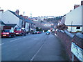
Hasland - Penmore
Location of BK Services (Training and Support Services for Vulnerable Adults).
Image: © Alan Heardman
Taken: 24 Feb 2007
0.07 miles
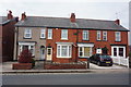
2
Hasland Road and Penmore Close
Chesterfield's crooked spire can be seen in the distance.
Image: © Alan Heardman
Taken: 24 Feb 2007
0.10 miles
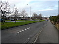
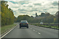
5
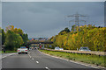
Chesterfield : The A617
Looking along the A617 as it heads into Chesterfield.
Image: © Lewis Clarke
Taken: 30 Sep 2018
0.16 miles
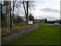
6
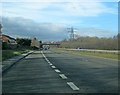
A617 approaching Chesterfield
From a long lay-by looking north-west down the hill towards the town centre behind the St Leonards Drive bridge.
Image: © Trevor Rickard
Taken: 26 Feb 2011
0.17 miles
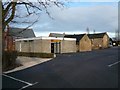
7
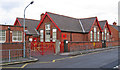
Hasland - Infant School
On Eyre Street East.
Image: © Dave Bevis
Taken: 15 Dec 2013
0.19 miles
8
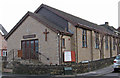
Hasland - Baptist Church
On Eyre Street East.
Image: © Dave Bevis
Taken: 15 Dec 2013
0.22 miles
9
Chesterfield : The A617
Heading out of Chesterfield on the A617.
Image: © Lewis Clarke
Taken: 2 Oct 2018
0.22 miles