IMAGES TAKEN NEAR TO
Smithfield Avenue, CHESTERFIELD, S41 0PS
Introduction
This page details the photographs taken nearby to Smithfield Avenue, S41 0PS by members of the Geograph project.
The Geograph project started in 2005 with the aim of publishing, organising and preserving representative images for every square kilometre of Great Britain, Ireland and the Isle of Man.

There are currently over 7.5m images from over14,400 individuals and you can help contribute to the project by visiting https://www.geograph.org.uk
Image Map
Images are licensed for reuse under creativecommons.org/licenses/by-sa/2.0
Notes
- Clicking on the map will re-center to the selected point.
- The higher the marker number, the further away the image location is from the centre of the postcode.
Image Listing (32 Images Found)
Images are licensed for reuse under creativecommons.org/licenses/by-sa/2.0
Image
Details
Distance
1
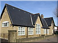
Hasland - Junior School
Now a "Surestart Centre".
Image: © Dave Bevis
Taken: 15 Mar 2009
0.06 miles
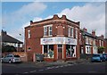
2
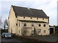
Hasland - former Methodist church
This building on The Green would appear to be the former Wesleyan Methodist church. For information on all three of the Methodist churches that existed in Hasland, please see http://www.chesterfieldmethodists.org.uk/hasland/ .
Image: © Dave Bevis
Taken: 15 Dec 2013
0.11 miles
4
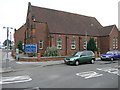
UPVC Stained Glass
Hasland Methodist Church has been glazed with stained glass in UPVC frames which look like they may also be double glazed. And why not?
Image: © Michael Patterson
Taken: 28 Jun 2006
0.14 miles
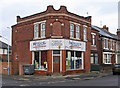
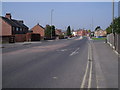
5
Carpet shop in Hasland
Where Hampton Street meets York Street.
Image: © Neil Theasby
Taken: 17 Oct 2014
0.15 miles
8
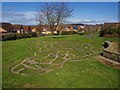
'Walk the View'
Created by Julia Hilton in 2004 as part of Chesterfield Borough Council's 'Percent for Art' programme the artwork is a map in sandstone, slate and bronze depicting the footpaths, tracks, rivers and streams from Hasland to the horizon.
Image: © Graham Hogg
Taken: 29 Mar 2021
0.17 miles
9
Walk the View by Julia Hilton
"Walk the View was commissioned for Chesterfield Council for the public space in a new housing estate. It is a giant brick, stone and slate map marking all the footpaths within a five mile radius of the Hasland Estate, taking in the edge of the moors in view of the site."
For full story from 2004 see; http://www.juliahilton.co.uk/walk-the-view/
Image: © Chris Morgan
Taken: 29 Mar 2021
0.17 miles
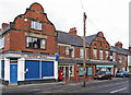
10
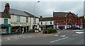
Shops in Hasland
By the busy roundabout on Hasland Road at the junction with The Green, B6039 and B6038 respectively.
Image: © Andrew Hill
Taken: 23 May 2011
0.18 miles