IMAGES TAKEN NEAR TO
Norwood Avenue, CHESTERFIELD, S41 0NJ
Introduction
This page details the photographs taken nearby to Norwood Avenue, S41 0NJ by members of the Geograph project.
The Geograph project started in 2005 with the aim of publishing, organising and preserving representative images for every square kilometre of Great Britain, Ireland and the Isle of Man.

There are currently over 7.5m images from over14,400 individuals and you can help contribute to the project by visiting https://www.geograph.org.uk
Image Map
Images are licensed for reuse under creativecommons.org/licenses/by-sa/2.0
Notes
- Clicking on the map will re-center to the selected point.
- The higher the marker number, the further away the image location is from the centre of the postcode.
Image Listing (13 Images Found)
Images are licensed for reuse under creativecommons.org/licenses/by-sa/2.0
Image
Details
Distance
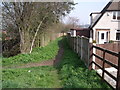
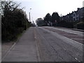
3
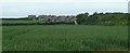
Fields towards the edge of town
There are large fields either side of Furnace Hillock road, largely unseen behind hedges. Here is a glimpse towards the Hasland edge of Chesterfield.
Image: © Andrew Hill
Taken: 23 May 2011
0.19 miles
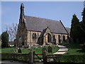
5
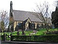
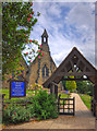
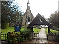
Hasland - St Paul's Church
St Paul's is the Church of England parish church of Hasland. There has been a church here since 1850 when Ven. Thomas Hill, Archdeacon of Chesterfield and Vicar of the Crooked Spire built the present church. See http://www.derbyshirechurches.org.uk/church/hasland-st-paul for more details.
Image: © Dave Bevis
Taken: 15 Apr 2015
0.22 miles
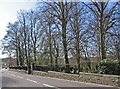
7
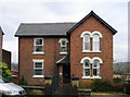
Hasland - Mansfield Road No 273
Probably the finest house in an otherwise architecturely-undistinguished grid square. I suspect that this was either built by or inspired by the Great Central Railway, whose "Chesterfield Loop" line was a couple of hundred yards behind the house.
Image: © Dave Bevis
Taken: 22 Nov 2010
0.23 miles