IMAGES TAKEN NEAR TO
Kariba Close, CHESTERFIELD, S41 0FP
Introduction
This page details the photographs taken nearby to Kariba Close, S41 0FP by members of the Geograph project.
The Geograph project started in 2005 with the aim of publishing, organising and preserving representative images for every square kilometre of Great Britain, Ireland and the Isle of Man.

There are currently over 7.5m images from over14,400 individuals and you can help contribute to the project by visiting https://www.geograph.org.uk
Image Map
Images are licensed for reuse under creativecommons.org/licenses/by-sa/2.0
Notes
- Clicking on the map will re-center to the selected point.
- The higher the marker number, the further away the image location is from the centre of the postcode.
Image Listing (378 Images Found)
Images are licensed for reuse under creativecommons.org/licenses/by-sa/2.0
Image
Details
Distance
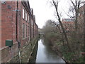
2
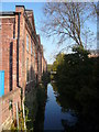
River Rother
View from A632 roadbridge, the building on the left is part of the former Markham Works complex (now apartments). Just off picture to the right is the new and nearly completed Piccadilly Heights apartment block.
Image: © Alan Heardman
Taken: 23 Oct 2007
0.07 miles
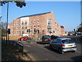
4
Flats by Piccadilly Road
Towards the traffic lights at the junction with Hady Hill, the A632.
Image: © Andrew Hill
Taken: 5 Mar 2011
0.09 miles
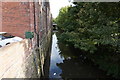
5
The River Rother from the bridge at the foot of Hady Hill
Image: © John Slater
Taken: 22 Mar 2016
0.10 miles
6
Piccadilly Heights
View from the junction at the bottom of Hady Hill.
Image: © Alan Heardman
Taken: 23 Oct 2007
0.10 miles
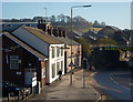
7
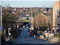
Looking along Hady Hill and Hollis Lane into Chesterfield
View into town from the foot of the hill which brings the A632 west into Chesterfield from Bolsover.
Image: © Andrew Hill
Taken: 16 Nov 2010
0.10 miles
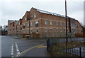
8
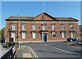
Former headquarters, Markham and Company Limited
A former ironworks and steelworks company which closed in 1998.
Image: © Andrew Hill
Taken: 29 Sep 2011
0.10 miles
9
Hollis Lane, Chesterfield
A pub and a few houses tucked between the elevated A61 and the railway. The view is from the steps for the pedestrian underpass.
Image: © Andrew Hill
Taken: 16 Nov 2010
0.10 miles
10
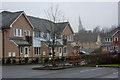
New houses near the river Rother, Chesterfield
Looking from the river path to houses on Wain Avenue which runs parallel to the river. The crooked spire can be seen in the mist.
Image: © Andrew Hill
Taken: 5 Mar 2011
0.10 miles