IMAGES TAKEN NEAR TO
Hady Crescent, CHESTERFIELD, S41 0EB
Introduction
This page details the photographs taken nearby to Hady Crescent, S41 0EB by members of the Geograph project.
The Geograph project started in 2005 with the aim of publishing, organising and preserving representative images for every square kilometre of Great Britain, Ireland and the Isle of Man.

There are currently over 7.5m images from over14,400 individuals and you can help contribute to the project by visiting https://www.geograph.org.uk
Image Map
Images are licensed for reuse under creativecommons.org/licenses/by-sa/2.0
Notes
- Clicking on the map will re-center to the selected point.
- The higher the marker number, the further away the image location is from the centre of the postcode.
Image Listing (17 Images Found)
Images are licensed for reuse under creativecommons.org/licenses/by-sa/2.0
Image
Details
Distance
1
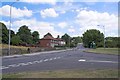
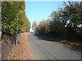
A632 Hady Hill junction with Cemetery Road
Hady Hill continues towards Calow, with the Cemetery Road junction on the right. A roman road runs through the trees behind the bus shelter alongside the A632.
Image: © Stephen G Taylor
Taken: 28 Jul 2006
0.08 miles
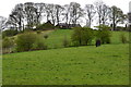
8
Chesterfield - Tapton Golf Course
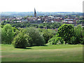
The footpath down across the golf course provides a panoramic view over Chesterfield town centre.
Image: © Dave Bevis
Taken: 8 May 2011
0.18 miles
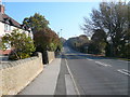
9

Chesterfield golf course and view of the town
A public footpath crosses the course, with views directly ahead to the famous crooked spire.
Image: © Andrew Hill
Taken: 5 Mar 2011
0.19 miles
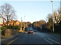
10
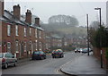
Piccadilly Road south from Wain Avenue, Chesterfield
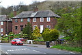
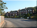
Traditional housing with hillside rising behind.
Image: © Andrew Hill
Taken: 5 Mar 2011
0.22 miles