IMAGES TAKEN NEAR TO
Yeldersley Close, CHESTERFIELD, S40 4LG
Introduction
This page details the photographs taken nearby to Yeldersley Close, S40 4LG by members of the Geograph project.
The Geograph project started in 2005 with the aim of publishing, organising and preserving representative images for every square kilometre of Great Britain, Ireland and the Isle of Man.

There are currently over 7.5m images from over14,400 individuals and you can help contribute to the project by visiting https://www.geograph.org.uk
Image Map
Images are licensed for reuse under creativecommons.org/licenses/by-sa/2.0
Notes
- Clicking on the map will re-center to the selected point.
- The higher the marker number, the further away the image location is from the centre of the postcode.
Image Listing (7 Images Found)
Images are licensed for reuse under creativecommons.org/licenses/by-sa/2.0
Image
Details
Distance
1
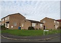
Yeldersley Close - suburbs of Chesterfield
Image: © Neil Theasby
Taken: 26 Nov 2013
0.03 miles
2
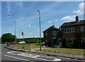
Pennine Way, Chesterfield
A Long-Distance road at Loundsley Green, Chesterfield.
Image: © Peter Barr
Taken: 28 Jun 2010
0.13 miles
3
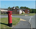
Suburban street scene, Loundsley Green
Postbox, bungalows and flats, Holme Hall Crescent.
Image: © Andrew Hill
Taken: 3 Jun 2011
0.18 miles
5
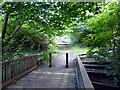
Footbridge over Holme Brook
In Holmebrook Valley Park
Image: © Graham Hogg
Taken: 11 Aug 2014
0.19 miles
6
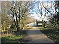
Bridleway passing under Loundsley Green Road
Image: © John Slater
Taken: 19 Feb 2014
0.20 miles
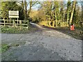
7
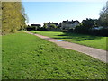
Public bridleway in the valley of Holme Brook
A green finger heading towards the centre of Chesterfield. The houses are in Berwyn Close and Hambledon Close.
Image: © Christine Johnstone
Taken: 18 Oct 2018
0.23 miles