IMAGES TAKEN NEAR TO
Haddon Close, CHESTERFIELD, S40 3BB
Introduction
This page details the photographs taken nearby to Haddon Close, S40 3BB by members of the Geograph project.
The Geograph project started in 2005 with the aim of publishing, organising and preserving representative images for every square kilometre of Great Britain, Ireland and the Isle of Man.

There are currently over 7.5m images from over14,400 individuals and you can help contribute to the project by visiting https://www.geograph.org.uk
Image Map
Images are licensed for reuse under creativecommons.org/licenses/by-sa/2.0
Notes
- Clicking on the map will re-center to the selected point.
- The higher the marker number, the further away the image location is from the centre of the postcode.
Image Listing (23 Images Found)
Images are licensed for reuse under creativecommons.org/licenses/by-sa/2.0
Image
Details
Distance
1
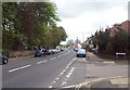
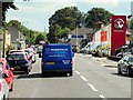
Chatsworth Road in Chesterfield
The A619 road which is a main arterial route into the town from the west. This picture shows the junction with Haddon Close and the famous twisted spire in the distance.
Image: © Jonathan Clitheroe
Taken: 5 May 2012
0.08 miles
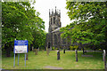
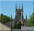
3
Brampton - St Thomas Church tower
For an alternative view, please see Andrew Hill's Image
Image: © Dave Bevis
Taken: 7 Oct 2012
0.10 miles
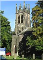
4
St Thomas's Church in Brampton, Chesterfield
Image: © Neil Theasby
Taken: 26 Nov 2013
0.10 miles
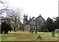
6
Glimpse of a church from Heaton Street
St Thomas' Brampton, further west along Chatsworth Road - a glimpse of the tower over the rooftops.
Image: © Andrew Hill
Taken: 3 Jun 2011
0.12 miles
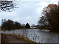
7

Path by Walton Dam
A pleasant place for residents of Brampton and Walton, by the side of a former mill reservoir in the valley of the River Hipper. Autumn mist is still lingering into the afternoon.
Image: © Bill Boaden
Taken: 13 Nov 2022
0.12 miles
8
Walton Dam
On the skyline is Chesterfield's famous crooked spire.
Image: © Graham Hogg
Taken: 30 Jan 2013
0.13 miles
9
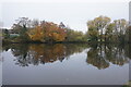
Walton Dam
A reservoir constructed to power a former corn mill. It is now a pleasant enclave amongst a lot of new housing in Walton.
Image: © Bill Boaden
Taken: 13 Nov 2022
0.14 miles
10
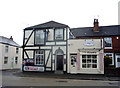
The Star public house, Brampton
On Chatsworth Road (A619).
Image: © JThomas
Taken: 28 Jul 2016
0.16 miles