IMAGES TAKEN NEAR TO
Hucklow Avenue, CHESTERFIELD, S40 2LT
Introduction
This page details the photographs taken nearby to Hucklow Avenue, S40 2LT by members of the Geograph project.
The Geograph project started in 2005 with the aim of publishing, organising and preserving representative images for every square kilometre of Great Britain, Ireland and the Isle of Man.

There are currently over 7.5m images from over14,400 individuals and you can help contribute to the project by visiting https://www.geograph.org.uk
Image Map
Images are licensed for reuse under creativecommons.org/licenses/by-sa/2.0
Notes
- Clicking on the map will re-center to the selected point.
- The higher the marker number, the further away the image location is from the centre of the postcode.
Image Listing (21 Images Found)
Images are licensed for reuse under creativecommons.org/licenses/by-sa/2.0
Image
Details
Distance
1
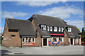
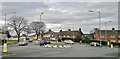
Chesterfield - The Whitecotes
On Boythorpe Road.
Image: © Dave Bevis
Taken: 2 Jun 2013
0.08 miles
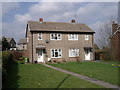
2
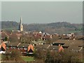
Boythorpe Rooftops with Parish Church in distance
Image: © Stephen G Taylor
Taken: 16 Feb 2005
0.12 miles
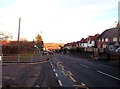
3
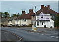
Boythorpe Road - houses and chip shop
Looking along the road past the junction with Clarkson Avenue to the right.
Image: © Andrew Hill
Taken: 23 May 2011
0.12 miles
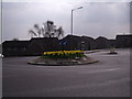
4
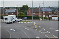
Roundabout at top of St Augustine's Road, Chesterfield
Image: © Chris Morgan
Taken: 18 Feb 2014
0.13 miles
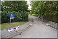
8
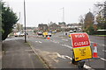
Road closure on Boythorpe Road
The closure is on St Augustine's Road round to the left. It had been completely closed but is now open for westbound traffic only.
Image: © Bill Boaden
Taken: 13 Nov 2022
0.15 miles
9
Whitecotes Lane in Chesterfield
In the Walton area, south of Chesterfield town centre.
Image: © Jonathan Clitheroe
Taken: 17 Nov 2012
0.16 miles