1
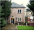
Elder Way, Chesterfield, Derbys.
The Grade II* listed Unitarian Chapel dating from 1694. This is the west facade that faces Elder Way.
Image: © David Hallam-Jones
Taken: 22 Nov 2014
0.01 miles
2
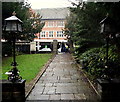
Elder Way, Chesterfield, Derbys.
This is the view towards Elder Way from the west end of this Unitarian Chapel. The gates and piers are included in the Grade II* listing. Known as The Elder Yard Chapel, it was completed in 1694 and was the first non-conformist church building in Chesterfield. The large Midlands Co-operative Society department store opposite closed in 2013.
Image: © David Hallam-Jones
Taken: 22 Nov 2014
0.01 miles
3
Chesterfield Shambles
The mediaeval heart of the town is the Shambles, with narrow lanes. One of the oldest buildings is the 'Royal Oak' pub with its distinctive jettied structure.
Image: © sue hayton
Taken: 14 Jun 2003
0.01 miles
4
Unitarian Chapel c1694, Elder Way
Image: © Stanley Walker
Taken: 10 Aug 2010
0.02 miles
5
Knifesmithgate, Chesterfield
Distinctive timber framed buildings with a covered pedestrian colonnade. The church spire can be seen in the background.
Image: © Andrew Hill
Taken: 16 Nov 2010
0.02 miles
6
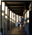
Pedestrian colonnade, Knifesmithgate
A covered pavement by the timber framed shops on Knifesmithgate, Chesterfield.
Image: © Andrew Hill
Taken: 16 Nov 2010
0.02 miles
7
Chesterfield - Elder Way and Knifesmithgate Junction
Image: © Alan Heardman
Taken: 22 Nov 1999
0.02 miles
8
Bottle & Thyme, Elder Way
Previously Barclays Bank. The western end of the Victoria Centre complex, designed by Jackson and Fryer as part of the redevelopment and extension of Knifesmithgate and completed in 1930.
Image: © Alan Murray-Rust
Taken: 15 Jun 2021
0.03 miles
9
Chesterfield - Co-operative Store
This is the Elder Way frontage. For the Knifesmithsgate frontage, please see
Image Note the "stock clearance" posters in the windows - this is one of six "fashion and home" stores that the Midlands Cooperative Society plans to close during 2013.
Image: © Dave Bevis
Taken: 26 May 2013
0.03 miles
10
Chesterfield - shops on Knifesmithgate
The half-timbered frontages as seen from Packers Row.
Image: © Dave Bevis
Taken: 13 Mar 2013
0.03 miles


