IMAGES TAKEN NEAR TO
Beetwell Street, CHESTERFIELD, S40 1SH
Introduction
This page details the photographs taken nearby to Beetwell Street, S40 1SH by members of the Geograph project.
The Geograph project started in 2005 with the aim of publishing, organising and preserving representative images for every square kilometre of Great Britain, Ireland and the Isle of Man.

There are currently over 7.5m images from over14,400 individuals and you can help contribute to the project by visiting https://www.geograph.org.uk
Image Map
Images are licensed for reuse under creativecommons.org/licenses/by-sa/2.0
Notes
- Clicking on the map will re-center to the selected point.
- The higher the marker number, the further away the image location is from the centre of the postcode.
Image Listing (618 Images Found)
Images are licensed for reuse under creativecommons.org/licenses/by-sa/2.0
Image
Details
Distance
1
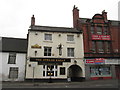
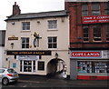
The Spread Eagle, Beetwell Street, Chesterfield
Image: © John Slater
Taken: 22 Mar 2016
0.00 miles
2
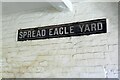
Spread Eagle Yard, Chesterfield
Chesterfield seems to have favoured enamel over cast iron for many of its street name signs.
Image: © Alan Murray-Rust
Taken: 15 Jun 2021
0.01 miles
3
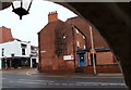
Beetwell Street, Chesterfield, Derbys.
South Street, on the north side of Beetwell Street, is seen here from the arched carriageway of the Grade II-listed "Spread Eagle" pub.
Image: © David Hallam-Jones
Taken: 22 Nov 2014
0.01 miles
4
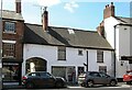
9 Beetwell Street, Chesterfield
The building dates back to around 1600, with later alterations, and retains interior features from this time and later 17th and 18th centuries. Listed Grade II*, one of just 8 Grade I or II* Listings in the town.
Image: © Alan Murray-Rust
Taken: 15 Jun 2021
0.01 miles
5
Beetwell Street, Chesterfield, Derbys.
As one of the oldest pubs in Chesterfield "The Spread Eagle" is Grade II-listed. Here the late C18th/early C19th façade is seen with its arched carriageway entrance under its west side.
Image: © David Hallam-Jones
Taken: 22 Nov 2014
0.01 miles
6
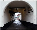
Beetwell Street, Chesterfield, Derbys.
The arched carriageway entrance under the west side of "The Spread Eagle" pub, with access to Markham Road (the A619) in the distance. The pub is Grade II-listed on account of its late C18th/early C19th façade and this archway, amongst other features.
Image: © David Hallam-Jones
Taken: 22 Nov 2014
0.01 miles
7
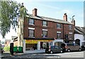
15-11 Beetwell Street, Chesterfield
Late 18th century houses, Listed Grade II as two separate Listings (15/13;11). There are separately Listed workshop buildings to the rear. http://www.geograph.org.uk/photo/6883025 http://www.geograph.org.uk/photo/6883027
Image: © Alan Murray-Rust
Taken: 15 Jun 2021
0.01 miles
8
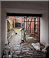
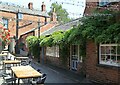
Beetwell Street, Chesterfield, Derbys.
Cannon Court is part of a range of Grade II-listed late C18th/early C19th buildings that are currently being used as craftsmen's workshops. In the distance past however, it seems that a blacksmith had his shop here.
Image: © David Hallam-Jones
Taken: 22 Nov 2014
0.01 miles
9
Cannon Court, Chesterfield
At the rear of 11 and 13 Beetwell Street. Classic burgage plot development of business premises – probably a blacksmith – to the rear of the street-front houses, probably 18th century. Listed Grade II, now modernised as small craft workshops.
Image: © Alan Murray-Rust
Taken: 15 Jun 2021
0.01 miles
10
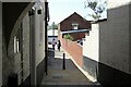
Spread Eagle Yard, Chesterfield
A typical narrow lane associated with burgage plot development from the medieval period. Originally it would have continued down to the River Hipper.
Image: © Alan Murray-Rust
Taken: 15 Jun 2021
0.02 miles