IMAGES TAKEN NEAR TO
New Beetwell Street, CHESTERFIELD, S40 1QN
Introduction
This page details the photographs taken nearby to New Beetwell Street, S40 1QN by members of the Geograph project.
The Geograph project started in 2005 with the aim of publishing, organising and preserving representative images for every square kilometre of Great Britain, Ireland and the Isle of Man.

There are currently over 7.5m images from over14,400 individuals and you can help contribute to the project by visiting https://www.geograph.org.uk
Image Map
Images are licensed for reuse under creativecommons.org/licenses/by-sa/2.0
Notes
- Clicking on the map will re-center to the selected point.
- The higher the marker number, the further away the image location is from the centre of the postcode.
Image Listing (667 Images Found)
Images are licensed for reuse under creativecommons.org/licenses/by-sa/2.0
Image
Details
Distance
1
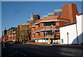
New Beetwell Street, Chesterfield
Modern buildings on the southern edge of the main pedestrianised shopping area. The library is one of the major buildings.
Image: © Andrew Hill
Taken: 16 Nov 2010
0.01 miles
3
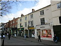
Low Pavement, Chesterfield
Eighteenth and early nineteenth century facades.
Image: © Jonathan Thacker
Taken: 24 Feb 2023
0.02 miles
4
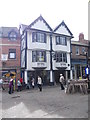
Former Falcon Inn - Low Pavement
This was a late 16th century coaching inn.
Image: © Betty Longbottom
Taken: 10 Sep 2012
0.03 miles
5
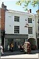
3, Low Pavement, Chesterfield
Town house of c.1800, Listed Grade II. The carriage arch formerly led into a typical long burgage plot yard with multiple dwellings and businesses, originally reaching right down to the River Hipper.
Image: © Alan Murray-Rust
Taken: 15 Jun 2021
0.03 miles
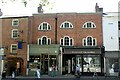
6
1 & 1A, Low Pavement, Chesterfield
Originally a single town house of the mid/late 18th century, later split into 2 with retail premises at ground level. Listed Grade II.
Image: © Alan Murray-Rust
Taken: 15 Jun 2021
0.03 miles
7
2 Central Pavement, Chesterfield
Early 19th century house with modern shop front, Listed Grade II.
Image: © Alan Murray-Rust
Taken: 15 Jun 2021
0.03 miles
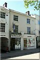
8
5 & 7, Low Pavement, Chesterfield
Originally a single town house of the mid/late 18th century, later split into 2 with retail premises at ground level. The left hand shop formerly belonged to the Thomas Lipton grocery chain http://www.geograph.org.uk/photo/6884262 . Listed Grade II.
Image: © Alan Murray-Rust
Taken: 15 Jun 2021
0.03 miles
9
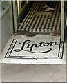
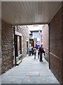
Entrance to 5 Low Pavement, Chesterfield
Thomas Lipton was a Glasgow grocer who developed a national chain of grocery stores. The name survives in the mosaic in the entrance; the tiling and glazed tile counter, just visible, date from the early 20th century, Art Nouveau style. Listed Grade II. See http://www.geograph.org.uk/photo/6884260 for location.
Image: © Alan Murray-Rust
Taken: 15 Jun 2021
0.03 miles
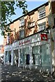
10
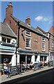
5 & 7 South Street, Chesterfield
Confusingly now a bar restaurant named No.10. 18th century facade, although some 17th century interior features survive. Listed Grade II.
Image: © Alan Murray-Rust
Taken: 15 Jun 2021
0.03 miles