IMAGES TAKEN NEAR TO
Knifesmithgate, CHESTERFIELD, S40 1AP
Introduction
This page details the photographs taken nearby to Knifesmithgate, S40 1AP by members of the Geograph project.
The Geograph project started in 2005 with the aim of publishing, organising and preserving representative images for every square kilometre of Great Britain, Ireland and the Isle of Man.

There are currently over 7.5m images from over14,400 individuals and you can help contribute to the project by visiting https://www.geograph.org.uk
Image Map
Images are licensed for reuse under creativecommons.org/licenses/by-sa/2.0
Notes
- Clicking on the map will re-center to the selected point.
- The higher the marker number, the further away the image location is from the centre of the postcode.
Image Listing (705 Images Found)
Images are licensed for reuse under creativecommons.org/licenses/by-sa/2.0
Image
Details
Distance
1
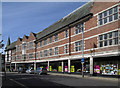
Chesterfield - Co-operative Store
This is the Elder Way frontage. For the Knifesmithsgate frontage, please see Image Note the "stock clearance" posters in the windows - this is one of six "fashion and home" stores that the Midlands Cooperative Society plans to close during 2013.
Image: © Dave Bevis
Taken: 26 May 2013
0.01 miles
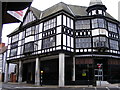
3
Former Co-operative department store, Knifesmithgate
Built in 1938 to complement the other black and white buildings adjacent. Redeveloped recently as Premier Inn with food and leisure outlets at ground level.
Image: © Alan Murray-Rust
Taken: 15 Jun 2021
0.02 miles
4
Knifesmithgate Shops
View west along Knifesmithgate, M&S is to the right and the back entrance to the Midlands Co-operative department store on the left.
Image: © Tim Marchant
Taken: 4 Feb 2009
0.02 miles
5
Chesterfield - Co-operative Store
The southern end of the Co-operative Department Store, viewed from Knifesmithgate. This is one of six "fashion and home" stores that the Midlands Cooperative Society plans to close during 2013.
Image: © Dave Bevis
Taken: 13 Mar 2013
0.03 miles
6
Former Co-op
The view of the shop closed in July 2013 on the corner of Elder Way in Chesterfield Town.
Image: © Gordon Griffiths
Taken: 20 Sep 2013
0.03 miles
7
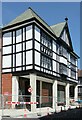
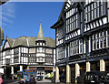
1 & 3 Knifesmithgate, Chesterfield
Built as part of the extension of Knifesmithgate in 1926, architects Wilcockson & Cutts, for the Home Brewery of Nottingham. The far end was (and is) The Queen's Head Hotel, the nearer end incorporating the car showrooms of Service Motors.
Image: © Alan Murray-Rust
Taken: 15 Jun 2021
0.03 miles
8
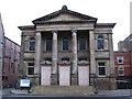
Elder Way, Chesterfield, Derbys.
The Grade II* listed Unitarian Chapel dating from 1694. This is the west facade that faces Elder Way.
Image: © David Hallam-Jones
Taken: 22 Nov 2014
0.03 miles
9
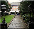
Elder Way, Chesterfield, Derbys.
This is the view towards Elder Way from the west end of this Unitarian Chapel. The gates and piers are included in the Grade II* listing. Known as The Elder Yard Chapel, it was completed in 1694 and was the first non-conformist church building in Chesterfield. The large Midlands Co-operative Society department store opposite closed in 2013.
Image: © David Hallam-Jones
Taken: 22 Nov 2014
0.03 miles
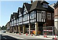
10
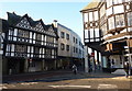
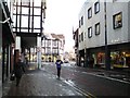
Corner of Knifesmithgate and Elder Way
Plenty of timber framed frontages, but also some starkly contrasting styles.
Image: © Andrew Hill
Taken: 16 Nov 2010
0.03 miles