IMAGES TAKEN NEAR TO
Rowland Street, SHEFFIELD, S3 8DE
Introduction
This page details the photographs taken nearby to Rowland Street, S3 8DE by members of the Geograph project.
The Geograph project started in 2005 with the aim of publishing, organising and preserving representative images for every square kilometre of Great Britain, Ireland and the Isle of Man.

There are currently over 7.5m images from over14,400 individuals and you can help contribute to the project by visiting https://www.geograph.org.uk
Image Map (Loading...)


Getting Data...Please wait
Leaflet Map data © OpenStreetMap
Images are licensed for reuse under creativecommons.org/licenses/by-sa/2.0
Notes
- Clicking on the map will re-center to the selected point.
- The higher the marker number, the further away the image location is from the centre of the postcode.
Image Listing (370 Images Found)
Images are licensed for reuse under creativecommons.org/licenses/by-sa/2.0
Image
Details
Distance
1
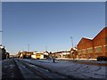
The Wilson Street coal dump
Dating from the 19th century, for many years rail-carried coal trucks would empty at this point.
Image: © Dave Pickersgill
Taken: 5 Mar 2024
0.02 miles
2
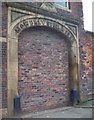
Facade of the Mowbray Street Steel Works
Bricked up facade of the Mowbray Street Steel Works which were registered under the name John Nicholson and Sons, makers of springknives, table knives and razors between 1847 and 1953.
The company became part of the Neepsend Steel and Tool Corporation whose head office was about a quarter of a mile away http://www.geograph.org.uk/photo/1301873 .
Image: © Jonathan Clitheroe
Taken: 7 Jun 2010
0.08 miles
3

The Mowbray in Sheffield
The Mowbray restaurant and wedding venue in Sheffield.
Image: © ben
Taken: 3 May 2021
0.08 miles
4
Andover Street, Woodside, Sheffield
Like Gray Street on the left of the tree and further down the hillside ... see ... Image ... in the 1970s this street was lined with houses like those on Pye Bank Road, see ... Image ... I wonder what will become of this area? It was givn a new lease of life 40 years ago, but now needs another.
Image: © Terry Robinson
Taken: 17 Mar 2010
0.09 miles
5
30 Mowbray Street, Sheffield
This rare survival of a mid-C19th back-to-back makes for rather a pathetic sight. Grade II listed.
Most of its contemporaries were cleared in the 1930s.
Image: © Stephen Richards
Taken: 13 Jun 2012
0.09 miles
7
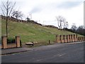
Demolished Housing, Pitsmoor Road, Woodside, Sheffield - 1
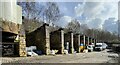
The original Woodside area comprised of many terraced back-to-back houses which were demolished in the 1960s to make way for a new housing development. The 'new' Woodside Estate was made up mainly of Apartment Blocks with four Large Blocks, two Medium Blocks and eleven Four Storey Blocks ... the majority of these Four Storey Blocks were on the land shown in this view, with the blocks running at right angles to the road. The steps shown in the picture ran between blocks seven and eight. A superb picture clarifying my description can be seen on Page 4 - Figure 3 - on this link ... http://www.sytimescapes.org.uk/files/uploads/pdfs/sheffield/S22_Sheffield_Late_20th_Century_Municipal_Suburbs.pdf ... The 'new' Woodside Estate has also been demolished, with little to show of where it stood except for the Brick Walls and Pillars shown, which separated the Apartment Blocks from each other. These Walls and Pillars look to have been built much later than the 1960s giving credence to on-line comments about the estate having been renovated shortly before demolition! For another view of this road see ... Image
Image: © Terry Robinson
Taken: 14 Feb 2010
0.10 miles
8
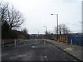
Pye Bank Road, Woodside, Sheffield
Pye Bank Road is 'closed off' for safety reasons half way along its length by this barrier. From this point there is no more housing so access isn't required. The brick and railing boundary on the right is from the 1970s Woodside Development ... the remnants of which are shown and described in this picture ... Image
Image: © Terry Robinson
Taken: 28 Feb 2010
0.11 miles
9
Cement works, Mowbray Street, Sheffield
Operated by Lafarge.
Image: © Stephen Richards
Taken: 13 Jun 2012
0.12 miles
10
Pye Bank Drive, Woodside, Sheffield
As see and described in ... Image ... Pye Bank Drive - which runs off Pye Bank Road at this point - is also 'closed off' to traffic at this point. The houses at the top of the hill are on Andover Street close to the former Pye Bank School.
Image: © Terry Robinson
Taken: 28 Feb 2010
0.12 miles