IMAGES TAKEN NEAR TO
New Smithy Drive, SHEFFIELD, S36 9RS
Introduction
This page details the photographs taken nearby to New Smithy Drive, S36 9RS by members of the Geograph project.
The Geograph project started in 2005 with the aim of publishing, organising and preserving representative images for every square kilometre of Great Britain, Ireland and the Isle of Man.

There are currently over 7.5m images from over14,400 individuals and you can help contribute to the project by visiting https://www.geograph.org.uk
Image Map
Images are licensed for reuse under creativecommons.org/licenses/by-sa/2.0
Notes
- Clicking on the map will re-center to the selected point.
- The higher the marker number, the further away the image location is from the centre of the postcode.
Image Listing (24 Images Found)
Images are licensed for reuse under creativecommons.org/licenses/by-sa/2.0
Image
Details
Distance
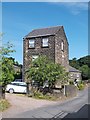
1
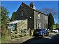
Semi-detached houses on High Bank Lane, Thurlstone
Image: © Neil Theasby
Taken: 17 Mar 2021
0.09 miles
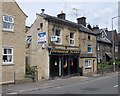

7
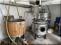
Kibble Brewery, Thurlstone
Located in old stables in the car park of the Crystal Palace.
Image: © Dave Pickersgill
Taken: 24 Sep 2022
0.12 miles

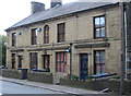
10
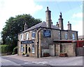
"The Crystal Palace" public house in Thurlstone
Image: © Neil Theasby
Taken: 26 Jul 2013
0.12 miles