IMAGES TAKEN NEAR TO
Manchester Road, SHEFFIELD, S36 9PS
Introduction
This page details the photographs taken nearby to Manchester Road, S36 9PS by members of the Geograph project.
The Geograph project started in 2005 with the aim of publishing, organising and preserving representative images for every square kilometre of Great Britain, Ireland and the Isle of Man.

There are currently over 7.5m images from over14,400 individuals and you can help contribute to the project by visiting https://www.geograph.org.uk
Image Map
Images are licensed for reuse under creativecommons.org/licenses/by-sa/2.0
Notes
- Clicking on the map will re-center to the selected point.
- The higher the marker number, the further away the image location is from the centre of the postcode.
Image Listing (27 Images Found)
Images are licensed for reuse under creativecommons.org/licenses/by-sa/2.0
Image
Details
Distance

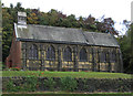
4
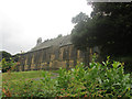
St Saviour's Church, Thurlstone
Built in 1905. Pevsner's Building's of England has a note that Mr G G Pace suggests that this church is unfinished. Perhaps the red-brick western gable end means that there was to have been a tower.
Image: © Humphrey Bolton
Taken: 10 Jul 2020
0.08 miles
5
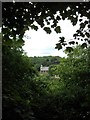
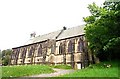
View of Thurlstone St Saviour's
Picture taken through a gap in the trees on the Transpennine Trail
Image: © Neil Theasby
Taken: 26 Jul 2013
0.08 miles
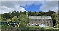
8
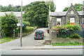
Bridleway passing a former chapel, Thurlstone
The bridleway is very steep, with steps it is part of the Kirkburton link to the TransPennine Trail, but is not suitable for cycling. The house was a Primitive Methodist Chapel that was opened in 1865 and replaced by a new building on the main road to the west by 1929. Perhaps it became too small for the congregation.
Image: © Humphrey Bolton
Taken: 10 Jul 2020
0.10 miles
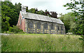
9
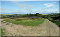
High Bank Lane, Thurlstone
In thought that this was a path junction, but the open area is at the edge of a disused quarry that is CRoW access land. The Westfield Lane junction is a little further on.
Image: © Humphrey Bolton
Taken: 16 Jul 2020
0.13 miles
10
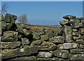
Emley Moor television mast
Seen from Far Bank Lane north of Millhouse Green
Image: © Neil Theasby
Taken: 17 Mar 2021
0.13 miles