IMAGES TAKEN NEAR TO
Birks Lane, SHEFFIELD, S36 9NB
Introduction
This page details the photographs taken nearby to Birks Lane, S36 9NB by members of the Geograph project.
The Geograph project started in 2005 with the aim of publishing, organising and preserving representative images for every square kilometre of Great Britain, Ireland and the Isle of Man.

There are currently over 7.5m images from over14,400 individuals and you can help contribute to the project by visiting https://www.geograph.org.uk
Image Map
Images are licensed for reuse under creativecommons.org/licenses/by-sa/2.0
Notes
- Clicking on the map will re-center to the selected point.
- The higher the marker number, the further away the image location is from the centre of the postcode.
Image Listing (17 Images Found)
Images are licensed for reuse under creativecommons.org/licenses/by-sa/2.0
Image
Details
Distance
2
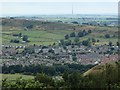
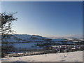
Millhouse Green from Hartcliff Hill
A view of the village from the hill to the south
Image: © Andrew Hill
Taken: 31 Jul 2013
0.09 miles
3
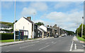
The A628 Manchester Road in Millhouse Green
Image: © Humphrey Bolton
Taken: 16 Jul 2020
0.09 miles
4
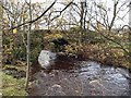
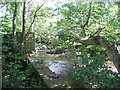
Bridge over the River Don near Millhouse Green
Image: © Steve Fareham
Taken: 15 Nov 2008
0.10 miles
5
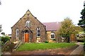
Thurlstone and Millhouse Green Methodist Church
Image: © Bill Henderson
Taken: Unknown
0.15 miles
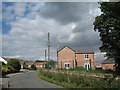
7
Above the houses of Millhouse green.
View from the High bank path.
Image: © steven ruffles
Taken: 27 Dec 2014
0.16 miles
9
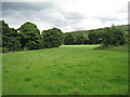
Field by the River Don at Millhouse Green
Image: © Jonathan Thacker
Taken: 23 Jul 2010
0.17 miles
10
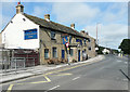
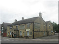
The Blacksmith's Arms, Millhouse Green
Named on the 1850 six-inch map.
Image: © Humphrey Bolton
Taken: 16 Jul 2020
0.18 miles