IMAGES TAKEN NEAR TO
Talbot Road, SHEFFIELD, S36 9ED
Introduction
This page details the photographs taken nearby to Talbot Road, S36 9ED by members of the Geograph project.
The Geograph project started in 2005 with the aim of publishing, organising and preserving representative images for every square kilometre of Great Britain, Ireland and the Isle of Man.

There are currently over 7.5m images from over14,400 individuals and you can help contribute to the project by visiting https://www.geograph.org.uk
Image Map (Loading...)


Getting Data...Please wait
Leaflet Map data © OpenStreetMap
Images are licensed for reuse under creativecommons.org/licenses/by-sa/2.0
Notes
- Clicking on the map will re-center to the selected point.
- The higher the marker number, the further away the image location is from the centre of the postcode.
Image Listing (110 Images Found)
Images are licensed for reuse under creativecommons.org/licenses/by-sa/2.0
Image
Details
Distance
1
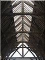
Penistone Market Hall roof
Penistone's market hall is the largest oak-framed building in the country built using historic methods with traditional materials. In 2011, it received the Best Community Project Award from South Yorkshire and Humber LABC Building Excellence.
Image: © Dave Pickersgill
Taken: 21 Aug 2012
0.03 miles
2
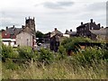
Penistone from the Trans Pennine Trail
Image: © John Fielding
Taken: 28 Jun 2007
0.06 miles
4
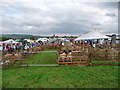
Penistone Show after a sudden localised downpour
Image: © Terry
Taken: 13 Sep 2008
0.06 miles
5
Coal drops, Penistone
These are alongside the former Woodhead railway line, which was opened in 1845.
Image: © Humphrey Bolton
Taken: 31 May 2020
0.08 miles
6
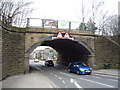
Disused railway bridge over bridge Street, Penistone
Now used by the Trans Pennine Trail.
Image: © JThomas
Taken: 12 Mar 2016
0.08 miles
7
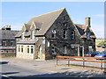
Penistone Launderette/Laundry
This building has been a laundry/laundrette since the 1960s, and there is now a physiotherapy and sports injury clinic upstairs.
Image: © David Ward
Taken: 31 Jul 2007
0.09 miles
8
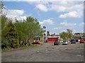
Penistone fire station
The car park in front of the fire station is a good point to access the Trans Pennine Trail.
Image: © Steve Fareham
Taken: 29 Apr 2009
0.11 miles
9
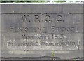
Old Bridge Marker by the A628, Penistone Bridge, Penistone Parish
Bridge Marker by the A628, in parish of Penistone (Barnsley District), Penistone Bridge, River Don, Cut into West parapet.
Surveyed
Milestone Society National ID: YW_PENTHU01br
Image: © Milestone Society
Taken: Unknown
0.12 miles
10
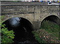
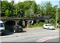
Penistone - A628 road bridge over River Don
Image: © Dave Bevis
Taken: 21 Sep 2011
0.12 miles