IMAGES TAKEN NEAR TO
Mayfield, SHEFFIELD, S36 8YN
Introduction
This page details the photographs taken nearby to Mayfield, S36 8YN by members of the Geograph project.
The Geograph project started in 2005 with the aim of publishing, organising and preserving representative images for every square kilometre of Great Britain, Ireland and the Isle of Man.

There are currently over 7.5m images from over14,400 individuals and you can help contribute to the project by visiting https://www.geograph.org.uk
Image Map
Images are licensed for reuse under creativecommons.org/licenses/by-sa/2.0
Notes
- Clicking on the map will re-center to the selected point.
- The higher the marker number, the further away the image location is from the centre of the postcode.
Image Listing (49 Images Found)
Images are licensed for reuse under creativecommons.org/licenses/by-sa/2.0
Image
Details
Distance
1
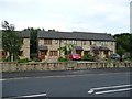
21st Century Cottages on Sheffield Road
Image: © Wendy North
Taken: 16 Aug 2008
0.05 miles
2
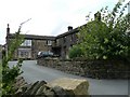
Toll Bar Farm
At one stge this building housed the village cobbler and a butcher as well as the farm. (Oxspring Heritage Group)
Image: © Wendy North
Taken: 16 Aug 2008
0.05 miles
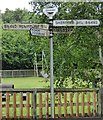
3
Signs for the Trans Pennine Trail with children's playground behind
Image: © Wendy North
Taken: 16 Aug 2008
0.05 miles
5
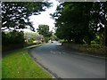
View down Roughbirchwood Road towards Sheffield Road
Image: © Wendy North
Taken: 19 Aug 2008
0.05 miles
6
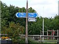
Old Direction Sign - Signpost by the B6462, Oxspring parish
Annulus and bar finial - 4 arms; Yorks WR halo with NGR by the B6462, in parish of Oxspring (Barnsley District), Oxspring, junction of Sheffield Road with Roughbirchworth Lane, against wooden fence of playground.
Surveyed
Milestone Society National ID: YW_SE2602
Image: © Milestone Society
Taken: Unknown
0.06 miles
7
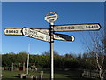
Which way now?
Road sign at Oxspring, near the children's playground. 'Yorks.W.R.' stands for 'West Riding of Yorkshire', which existed until the boundary changes of the early 1970s.
Image: © Dave Pickersgill
Taken: 18 Jan 2009
0.06 miles
9
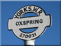
'Yorks.W.R.' sign at Oxspring
Detail of a road sign at Oxspring, near the children's playground. 'Yorks.W.R' stands for 'West Riding of Yorkshire', which existed until the boundary changes of the early 1970s.
Image: © Dave Pickersgill
Taken: 18 Jan 2009
0.07 miles
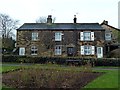
10
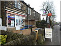
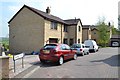
Oxspring: the post office
A small general store and post office set in what would originally have been an end-of-terrace house.
Image: © Chris Downer
Taken: 23 Apr 2012
0.07 miles