IMAGES TAKEN NEAR TO
High Royd Lane, SHEFFIELD, S36 7JR
Introduction
This page details the photographs taken nearby to High Royd Lane, S36 7JR by members of the Geograph project.
The Geograph project started in 2005 with the aim of publishing, organising and preserving representative images for every square kilometre of Great Britain, Ireland and the Isle of Man.

There are currently over 7.5m images from over14,400 individuals and you can help contribute to the project by visiting https://www.geograph.org.uk
Image Map
Images are licensed for reuse under creativecommons.org/licenses/by-sa/2.0
Notes
- Clicking on the map will re-center to the selected point.
- The higher the marker number, the further away the image location is from the centre of the postcode.
Image Listing (18 Images Found)
Images are licensed for reuse under creativecommons.org/licenses/by-sa/2.0
Image
Details
Distance
4
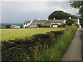
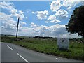
Drystone wall and fields south of Hoylandswaine.
A walk from Penistone.
Image: © steven ruffles
Taken: 6 May 2019
0.07 miles
5
High Royd farm shop sign, Hoylandswaine
Image: © Steve Fareham
Taken: 28 Jul 2012
0.11 miles
6
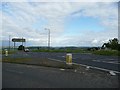
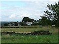
Junction of Barnsley Road Hoylandswaine with the A628 to Silkstone
I'm not sure when this stretch of road was built to bypass the village, but I'm sure the villagers are very relieved that it was. The settlement of High Royds can just be seen on the right of the photograph.
Image: © Wendy North
Taken: 22 Aug 2008
0.12 miles
7

Stone village sign at Hoylandswaine
Hoylandswaine - it's an odd name isn't it? The prefix "Hoyland" means "high farm" and is very probably derived from Old Norse as is the suffix "swaine" which may be after "Sveinn" the son of Ailric who died in 1129. Hence Hoylandswaine most likely means "the high farm of Sveinn"
Image: © Neil Theasby
Taken: 15 Nov 2010
0.13 miles
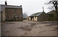
8
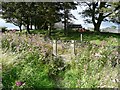
Stile into lane behind High Royds Farm
This was a particularly boggy part of the field which took careful negotiating. Himalayan Balsam was revelling in the very wet conditions.
Image: © Wendy North
Taken: 22 Aug 2008
0.13 miles
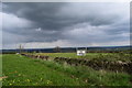
9
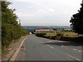
Barnsley Road Hoylandswaine
The white building is The Rose and Crown public house.
Image: © John Fielding
Taken: 24 Jun 2008
0.15 miles
10
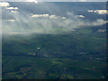
Hoylandswaine and Penistone from the air
Hoylandswaine is the settlement nearest the camera. The sunbeams are breaking through the clouds over Midhope Moors.
Image: © Thomas Nugent
Taken: 19 Oct 2018
0.15 miles