IMAGES TAKEN NEAR TO
Halifax Road, SHEFFIELD, S36 7EY
Introduction
This page details the photographs taken nearby to Halifax Road, S36 7EY by members of the Geograph project.
The Geograph project started in 2005 with the aim of publishing, organising and preserving representative images for every square kilometre of Great Britain, Ireland and the Isle of Man.

There are currently over 7.5m images from over14,400 individuals and you can help contribute to the project by visiting https://www.geograph.org.uk
Image Map
Images are licensed for reuse under creativecommons.org/licenses/by-sa/2.0
Notes
- Clicking on the map will re-center to the selected point.
- The higher the marker number, the further away the image location is from the centre of the postcode.
Image Listing (22 Images Found)
Images are licensed for reuse under creativecommons.org/licenses/by-sa/2.0
Image
Details
Distance
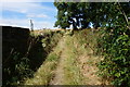
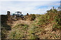
1
Bridleway off the A629, Penistone
This is Acre Lane and goes to Firs Lane.
Image: © Humphrey Bolton
Taken: 13 Jun 2020
0.06 miles
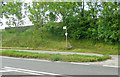
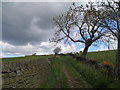
5
Car park for allotments alongside Well House Lane
Overlooking Penistone.
Image: © Steve Fareham
Taken: 28 Jul 2012
0.11 miles
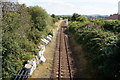
9
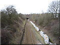
Railway towards Huddersfield
Looking north west from the bridge on Well House Lane towards the tunnel portal.
Image: © JThomas
Taken: 12 Mar 2016
0.14 miles
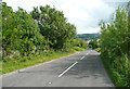
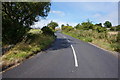
10
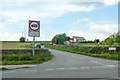
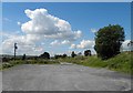
Crabtree Lane at the A629, Penistone
This is quite a busy Road, linking the A629 with the A635.
Image: © Humphrey Bolton
Taken: 13 Jun 2020
0.15 miles