IMAGES TAKEN NEAR TO
Spicer House Lane, SHEFFIELD, S36 7AF
Introduction
This page details the photographs taken nearby to Spicer House Lane, S36 7AF by members of the Geograph project.
The Geograph project started in 2005 with the aim of publishing, organising and preserving representative images for every square kilometre of Great Britain, Ireland and the Isle of Man.

There are currently over 7.5m images from over14,400 individuals and you can help contribute to the project by visiting https://www.geograph.org.uk
Image Map
Images are licensed for reuse under creativecommons.org/licenses/by-sa/2.0
Notes
- Clicking on the map will re-center to the selected point.
- The higher the marker number, the further away the image location is from the centre of the postcode.
Image Listing (7 Images Found)
Images are licensed for reuse under creativecommons.org/licenses/by-sa/2.0
Image
Details
Distance
1
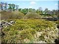
Bilberry patch, Royd Moor reservoir
Alongside the permissive path around the reservoir.
Image: © Christine Johnstone
Taken: 9 Apr 2011
0.10 miles
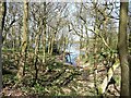
2
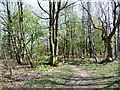
Footpath through the woods
Perimeter route round Royd Moor reservoir, looking anti-clockwise.
Image: © Christine Johnstone
Taken: 9 Apr 2011
0.10 miles
3
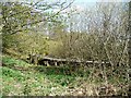
Conduit at Royd Moor reservoir
This plastic-lined channel runs all round the 'natural' edges of the reservoir. It seems to make some flows bypass the reservoir completely.
Image: © Christine Johnstone
Taken: 9 Apr 2011
0.17 miles
4
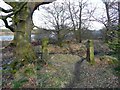
Stone gateposts in woodland to the west of Royd Moor Reservoir
Image: © Brian Webster
Taken: 1 Mar 2008
0.17 miles
5
Wooded inlet, Royd Moor reservoir
Seen from the permissive footpath.
Image: © Christine Johnstone
Taken: 9 Apr 2011
0.20 miles

7
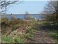
Walkers at Royd Moor reservoir
A permissive footpath goes all round the reservoir.
Image: © Christine Johnstone
Taken: 9 Apr 2011
0.24 miles