IMAGES TAKEN NEAR TO
Fullshaw Bank, SHEFFIELD, S36 6GB
Introduction
This page details the photographs taken nearby to Fullshaw Bank, S36 6GB by members of the Geograph project.
The Geograph project started in 2005 with the aim of publishing, organising and preserving representative images for every square kilometre of Great Britain, Ireland and the Isle of Man.

There are currently over 7.5m images from over14,400 individuals and you can help contribute to the project by visiting https://www.geograph.org.uk
Image Map
Images are licensed for reuse under creativecommons.org/licenses/by-sa/2.0
Notes
- Clicking on the map will re-center to the selected point.
- The higher the marker number, the further away the image location is from the centre of the postcode.
Image Listing (23 Images Found)
Images are licensed for reuse under creativecommons.org/licenses/by-sa/2.0
Image
Details
Distance
1
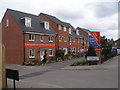
Show homes on Green Road
Maybe they will seem less red after a while to blend in with the stone houses in the rest of the area
Image: © John Slater
Taken: 31 Mar 2012
0.07 miles
2
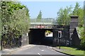
Green Road, Penistone - Bridge under the railway
Image: © Neil Theasby
Taken: 23 May 2012
0.09 miles
3
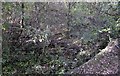
Turntable pit at the former Barnsley Junction Sidings
Nature is steadily reclaiming this blue brick turntable pit. the turntable was in use at what used to be Barnsley Junction Sidings which served the adjacent Penistone Steelworks. Very little evidence remains of these extensive sidings, now, which ran on to the Sheffield to Manchester Woodhead railway, although a little poking around in the shrubbery does turn up a few gems like this one.
Image: © Bobby Clegg
Taken: 12 Oct 2014
0.14 miles
4
Entering Penistone Via Long Lane
Looking towards the town centre from the Castle Green area.
Image: © Jonathan Clitheroe
Taken: 18 Mar 2011
0.16 miles
7
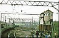
Huddersfield Junction, Penistone
Taken from the official farewell tour train, run just prior to closure of the Woodhead route in 1981. The Health & Safety crowd were not a factor in 1981, even on electrified railway lines. Almost all the infrastructure in the photograph is now just a memory.
Image: © Peter Whatley
Taken: Unknown
0.19 miles
9
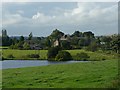
Castle Dam and the outskirts of Castle Green
Shephedrs Farm is the nearest of the buildings. See Image
Image: © Wendy North
Taken: 19 Aug 2008
0.21 miles
10
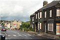
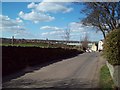
Sheffield Road
Penistone street scene
Image: © Richard Croft
Taken: 11 Sep 2010
0.21 miles