IMAGES TAKEN NEAR TO
Southgate, SHEFFIELD, S36 6EA
Introduction
This page details the photographs taken nearby to Southgate, S36 6EA by members of the Geograph project.
The Geograph project started in 2005 with the aim of publishing, organising and preserving representative images for every square kilometre of Great Britain, Ireland and the Isle of Man.

There are currently over 7.5m images from over14,400 individuals and you can help contribute to the project by visiting https://www.geograph.org.uk
Image Map
Images are licensed for reuse under creativecommons.org/licenses/by-sa/2.0
Notes
- Clicking on the map will re-center to the selected point.
- The higher the marker number, the further away the image location is from the centre of the postcode.
Image Listing (7 Images Found)
Images are licensed for reuse under creativecommons.org/licenses/by-sa/2.0
Image
Details
Distance
2
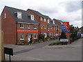
Show homes on Green Road
Maybe they will seem less red after a while to blend in with the stone houses in the rest of the area
Image: © John Slater
Taken: 31 Mar 2012
0.12 miles
3
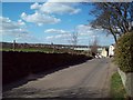
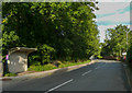
Entering Penistone Via Long Lane
Looking towards the town centre from the Castle Green area.
Image: © Jonathan Clitheroe
Taken: 18 Mar 2011
0.14 miles
4
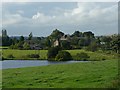
Castle Dam and the outskirts of Castle Green
Shephedrs Farm is the nearest of the buildings. See Image
Image: © Wendy North
Taken: 19 Aug 2008
0.19 miles
6
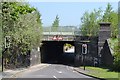
Green Road, Penistone - Bridge under the railway
Image: © Neil Theasby
Taken: 23 May 2012
0.24 miles