IMAGES TAKEN NEAR TO
Park Avenue, SHEFFIELD, S36 6DL
Introduction
This page details the photographs taken nearby to Park Avenue, S36 6DL by members of the Geograph project.
The Geograph project started in 2005 with the aim of publishing, organising and preserving representative images for every square kilometre of Great Britain, Ireland and the Isle of Man.

There are currently over 7.5m images from over14,400 individuals and you can help contribute to the project by visiting https://www.geograph.org.uk
Image Map (Loading...)


Getting Data...Please wait
Leaflet Map data © OpenStreetMap
Images are licensed for reuse under creativecommons.org/licenses/by-sa/2.0
Notes
- Clicking on the map will re-center to the selected point.
- The higher the marker number, the further away the image location is from the centre of the postcode.
Image Listing (107 Images Found)
Images are licensed for reuse under creativecommons.org/licenses/by-sa/2.0
Image
Details
Distance
1
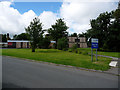
Green Park Old People's Home, Penistone now closed
Image: © Terry
Taken: 19 Jul 2008
0.09 miles
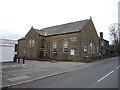
2
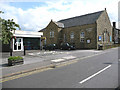
St Andrews Methodist Chapel and Penistone Library
Image: © Terry
Taken: 8 Sep 2008
0.09 miles
6
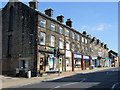
Penistone - Market Street
A row of shops on the eastern side of Market Street
Image: © David Ward
Taken: 31 Jul 2007
0.13 miles
8
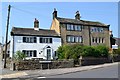
Penistone houses - corner of Clarel St & High St
Image: © Neil Theasby
Taken: 23 May 2012
0.14 miles
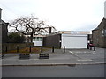
10
Market Hall, Penistone
Designed by WCEC Architects and built 2010-11. It is a cruck-framed timber building using traditional techniques.
Image: © Jonathan Thacker
Taken: 29 Sep 2017
0.14 miles