IMAGES TAKEN NEAR TO
Green Road, SHEFFIELD, S36 6BG
Introduction
This page details the photographs taken nearby to Green Road, S36 6BG by members of the Geograph project.
The Geograph project started in 2005 with the aim of publishing, organising and preserving representative images for every square kilometre of Great Britain, Ireland and the Isle of Man.

There are currently over 7.5m images from over14,400 individuals and you can help contribute to the project by visiting https://www.geograph.org.uk
Image Map
Images are licensed for reuse under creativecommons.org/licenses/by-sa/2.0
Notes
- Clicking on the map will re-center to the selected point.
- The higher the marker number, the further away the image location is from the centre of the postcode.
Image Listing (15 Images Found)
Images are licensed for reuse under creativecommons.org/licenses/by-sa/2.0
Image
Details
Distance
1
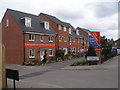
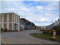
Show homes on Green Road
Maybe they will seem less red after a while to blend in with the stone houses in the rest of the area
Image: © John Slater
Taken: 31 Mar 2012
0.03 miles
2
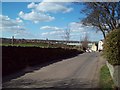
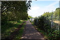
Entering Penistone Via Long Lane
Looking towards the town centre from the Castle Green area.
Image: © Jonathan Clitheroe
Taken: 18 Mar 2011
0.09 miles
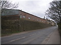
3
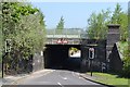
Green Road, Penistone - Bridge under the railway
Image: © Neil Theasby
Taken: 23 May 2012
0.11 miles
4
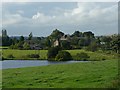
Castle Dam and the outskirts of Castle Green
Shephedrs Farm is the nearest of the buildings. See Image
Image: © Wendy North
Taken: 19 Aug 2008
0.13 miles
6
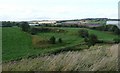
Partially filled quarry with industrial units behind
This last stretch of the walk brought us to the industrial edge of Penistone. The railway runs between where this photograph was taken and the industrial buildings.
I wonder if stone for building one or more of bridges along the railway had been extracted from this quarry.
Image: © Wendy North
Taken: 19 Aug 2008
0.19 miles
8
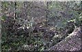
Turntable pit at the former Barnsley Junction Sidings
Nature is steadily reclaiming this blue brick turntable pit. the turntable was in use at what used to be Barnsley Junction Sidings which served the adjacent Penistone Steelworks. Very little evidence remains of these extensive sidings, now, which ran on to the Sheffield to Manchester Woodhead railway, although a little poking around in the shrubbery does turn up a few gems like this one.
Image: © Bobby Clegg
Taken: 12 Oct 2014
0.22 miles
10
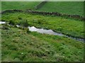
Castle Dike at the possible site of Kirkwood Mill
This may have been the original site of the Kirkwood Mill. There is certainly a good deal of stone buried in the bank at this point which has probably come from a building. This whole area along the stream is planted with Rowan trees and as we walked along I expected to come across a house and gardens which never happened. See Image
Image: © Wendy North
Taken: 19 Aug 2008
0.23 miles