IMAGES TAKEN NEAR TO
Hazlehead, Crow Edge, SHEFFIELD, S36 4HJ
Introduction
This page details the photographs taken nearby to S36 4HJ by members of the Geograph project.
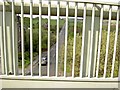
The Geograph project started in 2005 with the aim of publishing, organising and preserving representative images for every square kilometre of Great Britain, Ireland and the Isle of Man.

There are currently over 7.5m images from over14,400 individuals and you can help contribute to the project by visiting https://www.geograph.org.uk
Image Map (Loading...)


Getting Data...Please wait
Leaflet Map data © OpenStreetMap
Images are licensed for reuse under creativecommons.org/licenses/by-sa/2.0
Notes
- Clicking on the map will re-center to the selected point.
- The higher the marker number, the further away the image location is from the centre of the postcode.
Image Listing (14 Images Found)
Images are licensed for reuse under creativecommons.org/licenses/by-sa/2.0
Image
Details
Distance
1
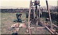
Shell and auger drilling
Geotechnical investigation for a new raw water pipeline to Langsett
Image: © James Wood
Taken: 17 Apr 1985
0.06 miles
2
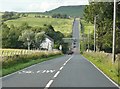
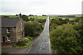
The A616, Dunford
Here is the sharp dip to cross the River Don. The new bridge carries the Trans-Pennine Trail, replacing the old railway bridge.
Image: © Humphrey Bolton
Taken: 21 Aug 2008
0.08 miles
3
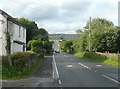
The Trans-Pennine Trail bridge over the A616, Hazlehead, Dunford
This has replaced the former railway bridge and is, presumably, a much lighter structure.
Image: © Humphrey Bolton
Taken: 21 Aug 2008
0.08 miles
4
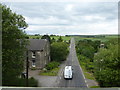
The A616 Whams Road at Hazlehead
Viewed from the Trans Pennine Trail footbridge
Image: © Graham Hogg
Taken: 7 Jul 2014
0.08 miles
5
The A616 road at Hazelhead
From the 'new' bridge on the Trans Pennine Trail.
Image: © Steve Fareham
Taken: 29 Apr 2009
0.09 miles
6
Whams Road
View north from the Trans-Pennine Trail bridge http://www.geograph.org.uk/photo/937569
Image: © Richard Croft
Taken: 11 Sep 2010
0.09 miles
7
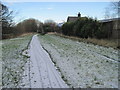
Hazlehead Bridge railway station (site)
Opened in 1846 by the Sheffield, Ashton-under-Lyne and Manchester Railway (which changed its name to the Manchester Sheffield and Lincolnshire Railway the following year), this station closed to passengers in 1950, and completely in 1964. The line closed in 1981. View east towards Penistone and Sheffield on a frosty morning.
Image: © Nigel Thompson
Taken: 17 Dec 2011
0.10 miles
8
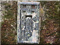
Ordnance Survey Flush Bracket 727
This can be found on the former Railway Hotel (now a private dwelling).
For more detail see : http://www.bench-marks.org.uk/log?bm_key=9926
Image: © Peter Wood
Taken: 3 Mar 2013
0.10 miles
9
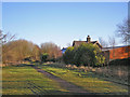
Site of Hazlehead Station
The site of a station on the formerly GCR line from Manchester to Sheffield. Now on the Transpennine Trail: http://www.transpenninetrail.org.uk/
Image: © John Illingworth
Taken: 9 Jan 2013
0.10 miles
10
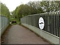
The Trans Pennine Trail crosses the A616 at Hazelhead
Image: © Steve Fareham
Taken: 29 Apr 2009
0.12 miles