IMAGES TAKEN NEAR TO
Flouch, SHEFFIELD, S36 4HH
Introduction
This page details the photographs taken nearby to Flouch, S36 4HH by members of the Geograph project.
The Geograph project started in 2005 with the aim of publishing, organising and preserving representative images for every square kilometre of Great Britain, Ireland and the Isle of Man.

There are currently over 7.5m images from over14,400 individuals and you can help contribute to the project by visiting https://www.geograph.org.uk
Image Map
Images are licensed for reuse under creativecommons.org/licenses/by-sa/2.0
Notes
- Clicking on the map will re-center to the selected point.
- The higher the marker number, the further away the image location is from the centre of the postcode.
Image Listing (12 Images Found)
Images are licensed for reuse under creativecommons.org/licenses/by-sa/2.0
Image
Details
Distance
1
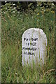
Milestone
A milestone on the Old Manchester Road, near the Flouch roundabout.
Image: © Dave Pickersgill
Taken: 5 Aug 2013
0.05 miles
2
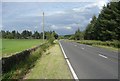
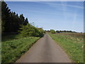
The A628, Langsett
Here the road approaches a bend to the right leading to the new roundabout junction. At the bend a bridleway goes off to the left, and also connects to the old main road, which goes straight forward.
Image: © Humphrey Bolton
Taken: 21 Aug 2008
0.10 miles
3
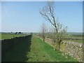
Bridleway, Dunford
This part of the route is a grass track, evidently not heavily used. This is not surprising because it is officially a 'dead-end' bridleway ending opposite Soughley Spring, a stone's throw from the Trans-Pennine Trail.
Image: © Humphrey Bolton
Taken: 20 Apr 2009
0.13 miles
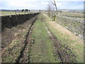
5
The old A628
When the Stocksbridge by-pass was built the Flouch interchange was 'improved' and a new section of road was constructed. This is a small section of the original Woodhead Road which now serves only as access to the houses a little further on.
Image: © Paul Glover
Taken: 17 Apr 2011
0.15 miles
6

Sun sets on pylons near The Flouch
The electricity power line in the picture is no longer there. It was replaced some time after 1963 by the line routed underground through the old railway tunnel from Dunford Bridge to Woodhead. The removal of the pylons was an improvement for this northeastern corner of the Peak District National Park, whose boundary lies alongside the A616 at this point.
Image: © Les Shaw
Taken: Unknown
0.19 miles
7
Old milestone
I cleaned and repainted this milestone on the Doncaster Saltersbrook turnpike of 1740 in 2016. It is on a piece of cut-off original road westwards from what was the Flouch Inn, now closed. On a visit in 2021 the lettering was refreshed, always difficult on these old weathered stones.
Image: © Chris Minto
Taken: 1 Aug 2021
0.19 miles
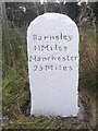
8
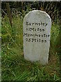
A Milestone Beside the Old Road (A628)
Looking eastward. The stone shows that Barnsley is 13 miles to the east and Manchester is 23 miles to the west.
Image: © Peter Wood
Taken: 2 Dec 2015
0.20 miles
9
A628 Woodhead pass lay-by near 'The Flouch'
Image: © Steve Fareham
Taken: 20 Jan 2009
0.20 miles
10
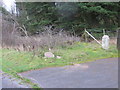
Old Milestone by Old Manchester Road, Barnsley
Carved stone post by the UC road (was A628), in parish of BARNSLEY (BARNSLEY District), Flouch on old section of A628 cut off by new road, near gateway 100m beyond walls built across verges, on South side of road. Erected by the Doncaster & Salter's Brook turnpike trust in the 18th century.
Inscription reads:-
Barnsley
11 Miles
Manchester
25 Miles
Grade II Listed. List Entry Number: 1151083
https://historicengland.org.uk/listing/the-list/list-entry/1151083
Milestone Society National ID: YS_BNMC11.
Image: © C Minto
Taken: 1 Mar 1993
0.20 miles