IMAGES TAKEN NEAR TO
Hazlehead, Crow Edge, SHEFFIELD, S36 4HG
Introduction
This page details the photographs taken nearby to S36 4HG by members of the Geograph project.
The Geograph project started in 2005 with the aim of publishing, organising and preserving representative images for every square kilometre of Great Britain, Ireland and the Isle of Man.

There are currently over 7.5m images from over14,400 individuals and you can help contribute to the project by visiting https://www.geograph.org.uk
Image Map (Loading...)


Getting Data...Please wait
Leaflet Map data © OpenStreetMap
Images are licensed for reuse under creativecommons.org/licenses/by-sa/2.0
Notes
- Clicking on the map will re-center to the selected point.
- The higher the marker number, the further away the image location is from the centre of the postcode.
Image Listing (7 Images Found)
Images are licensed for reuse under creativecommons.org/licenses/by-sa/2.0
Image
Details
Distance
1
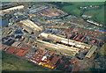
Hepworth Building Products: aerial 2001
With thanks to Robin Webster for identifying it, from the "Hepworth" on the chimney stack, which has since been demolished.
Today's view on Google Satellite View is less colourful, with much less stock.
Image: © Chris
Taken: 12 Dec 2001
0.04 miles
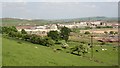
3
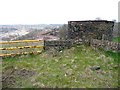
Probable mine shaft, A616
This one is not marked on OS maps, but there is a larger circular shaft nearby captioned "Air Shaft". There is an access hatch on the top, but only a small hole for ventilation, so perhaps this is the top of an access shaft.
Image: © Humphrey Bolton
Taken: 14 Apr 2009
0.17 miles
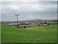
4
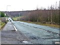
Pipeworks below Hepshaw, Dunford
This site started as a colliery, but is now a sprawling factory making clay pipes, surrounded by countryside.
Image: © Humphrey Bolton
Taken: 27 May 2004
0.17 miles
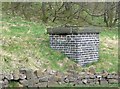
6
Mine Air Shaft, Dunford
So it says on the 1960s six-inch map, but it seems unusual for a mine shaft to be built of dry-stone walling. The Hepworth pipe works are in the background.
Image: © Humphrey Bolton
Taken: 14 Apr 2009
0.22 miles
7
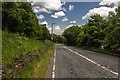
Whams Road at Sledbrook Crescent
The former turnpike road between Sheffield and Huddersfield, now the A616.
Image: © Christine Johnstone
Taken: 10 Jan 2012
0.23 miles