IMAGES TAKEN NEAR TO
Stocksbridge, SHEFFIELD, S36 4GS
Introduction
This page details the photographs taken nearby to S36 4GS by members of the Geograph project.
The Geograph project started in 2005 with the aim of publishing, organising and preserving representative images for every square kilometre of Great Britain, Ireland and the Isle of Man.

There are currently over 7.5m images from over14,400 individuals and you can help contribute to the project by visiting https://www.geograph.org.uk
Image Map
Images are licensed for reuse under creativecommons.org/licenses/by-sa/2.0
Notes
- Clicking on the map will re-center to the selected point.
- The higher the marker number, the further away the image location is from the centre of the postcode.
Image Listing (16 Images Found)
Images are licensed for reuse under creativecommons.org/licenses/by-sa/2.0
Image
Details
Distance
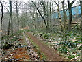
1
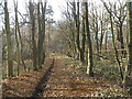
On the old railway in Sheephouse Wood
Part of the Barnsley Boundary Walk. The wire works can be seen through the trees on the right
Image: © John Slater
Taken: 29 Feb 2012
0.03 miles
2
Former Samuel Fox's wire making facility
Opened in 1963 and still producing wire for the Bridon Group in 2011, but now boarded up and silent, with a single security man guarding the main gate.
A very long and large works which can't have much of a future producing wire, or anything else. Demolition will probably come, but it may be many years before that can happen. The Barnsley Boundary Walk passes alongside, but the works are largely hidden behind trees.
Image: © Chris Morgan
Taken: 21 Mar 2016
0.04 miles
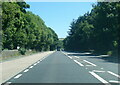
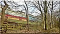
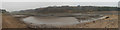
4
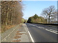
A616 towards Sheffield
Looking east on the north bank of Underbank Reservoir.
Image: © JThomas
Taken: 21 Mar 2019
0.08 miles
5
Path in Sheephouse Wood
The path, which forms part of the Barnsley Boundary Walk, here lies on the line of a narrow gauage railway used in the construction of Langsett Reservoir at the turn of the 20th century. Behind the path is the Sheephouse works, a building over 350m in length that once produced steel wire but now lies empty following its recent closure.
Image: © Graham Hogg
Taken: 21 Mar 2016
0.10 miles
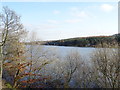
6
Underbank Reservoir
Underbank Reservoir is very low following a summer of drought.
Image: © Dave Pickersgill
Taken: 25 Nov 2018
0.13 miles
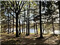
7
Underbank Reservoir
View through trees on the north bank.
Image: © JThomas
Taken: 21 Mar 2019
0.15 miles

10

Underbank Reservoir
The water level is lower than the usual for the time of year.
Image: © Dave Pickersgill
Taken: 9 Nov 2022
0.18 miles