IMAGES TAKEN NEAR TO
Fox Valley Way, SHEFFIELD, S36 2AE
Introduction
This page details the photographs taken nearby to Fox Valley Way, S36 2AE by members of the Geograph project.
The Geograph project started in 2005 with the aim of publishing, organising and preserving representative images for every square kilometre of Great Britain, Ireland and the Isle of Man.

There are currently over 7.5m images from over14,400 individuals and you can help contribute to the project by visiting https://www.geograph.org.uk
Image Map
Images are licensed for reuse under creativecommons.org/licenses/by-sa/2.0
Notes
- Clicking on the map will re-center to the selected point.
- The higher the marker number, the further away the image location is from the centre of the postcode.
Image Listing (145 Images Found)
Images are licensed for reuse under creativecommons.org/licenses/by-sa/2.0
Image
Details
Distance
1
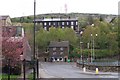
The road to nowhere
Tata site in the centre of Stocksbridge. This is soon to become a retail development.
Image: © Dave Pickersgill
Taken: 2 Jan 2012
0.01 miles
2
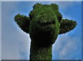
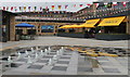
Green giraffe's head at Fox Valley Retail Park
Covered in artificial turf, this model of a giraffe stands fourteen feet tall and has no doubt been erected at considerable expense to engage and interest the children of passing shoppers.
Image: © Neil Theasby
Taken: 17 Feb 2018
0.01 miles
3

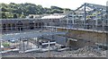
Fox Valley, Stocksbridge
Work continues as the Fox Valley Retail Site nears opening.
Image: © Dave Pickersgill
Taken: 5 Apr 2016
0.02 miles
4
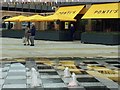
Fox Valley retail park opened last week #2
Image: © Steve Fareham
Taken: 20 Jun 2016
0.02 miles
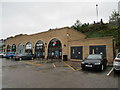
6
Fox Valley, Stocksbridge
The Fox Valley retail development on the morning after opening.
Image: © Dave Pickersgill
Taken: 17 Jun 2016
0.02 miles
7
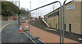
Fox Valley, Stocksbridge
Work continues on the 'upper level' bridleway as the Fox valley Site nears opening.
Image: © Dave Pickersgill
Taken: 5 Apr 2016
0.02 miles
8
Stocks Bridge at Stocksbridge
This picture links off to the left with the 'Samuel Fox' and 'Corus' pictures. The piece of road between 'The Lunchbox' and the 'Bollards' is actually a bridge over the original course of the Little Don (or Porter) River. This bridge was on some land owned by a John Stocks so it became known as Stocks Bridge ... so now you know!*** The 'Lunchbox' House and the Prospect Cottages Terrace behind are both shown on the 1903 Stocksbridge Map and will have seen many changes over the years.
Image
Image
*** Update in January 2014
There is now a doubt as to the truth of this information … with a current
thought being that it is more to do with the site of some Monastic Buildings
I'll try to verify this in due course
Image: © Terry Robinson
Taken: 30 Apr 2008
0.02 miles
9
Fox Valley Development, Stocksbridge
Image: © Dave Pickersgill
Taken: 24 Sep 2015
0.03 miles
10
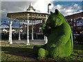
Big Green Bear
At Fox Valley Retail Park, Stocksbridge
Image: © Neil Theasby
Taken: 17 Feb 2018
0.03 miles