IMAGES TAKEN NEAR TO
Spink Hall Lane, SHEFFIELD, S36 1FL
Introduction
This page details the photographs taken nearby to Spink Hall Lane, S36 1FL by members of the Geograph project.
The Geograph project started in 2005 with the aim of publishing, organising and preserving representative images for every square kilometre of Great Britain, Ireland and the Isle of Man.

There are currently over 7.5m images from over14,400 individuals and you can help contribute to the project by visiting https://www.geograph.org.uk
Image Map
Images are licensed for reuse under creativecommons.org/licenses/by-sa/2.0
Notes
- Clicking on the map will re-center to the selected point.
- The higher the marker number, the further away the image location is from the centre of the postcode.
Image Listing (14 Images Found)
Images are licensed for reuse under creativecommons.org/licenses/by-sa/2.0
Image
Details
Distance
5
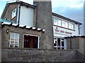
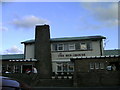
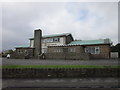
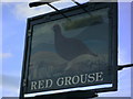
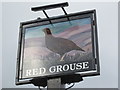
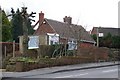
The Red Grouse Public House
One of a smattering of Sam Smith's pubs in the Sheffield area. Fans of this Tadcaster-based brewery may also wish to check out The Cow and Calf (Grenoside), The Old Mother Redcap (Bradway), The Royal Oak (Ulley) and the Brown Bear (Sheffield City Centre).
Image: © Jonathan Clitheroe
Taken: 1 Aug 2010
0.13 miles
7
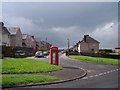
Kenworthy Road, Stocksbridge
These houses were built in late 1930's as part of the Glebelands Estate, located on the south of Stocksbridge and quite close to some open countryside at Stone Moor. I think the sky could be described as 'lowering' ... and it had just started raining! Handy looking Phone Box ... Image
Image: © Terry Robinson
Taken: 30 Apr 2008
0.15 miles
8
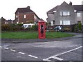
Handy Phone Box on Kenworthy Road, Stocksbridge
Perhaps it's not so handy after all ... Image
Image: © Terry Robinson
Taken: 7 Nov 2008
0.16 miles
9
Is this the smallest 'Chippy' in Yorkshire? ... maybe England ... the UK ... the World?
Mill's 'Chippy' in Stocksbridge
Image: © Terry Robinson
Taken: 17 Mar 2008
0.16 miles
10
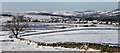
View from Walder's Low
The view from Walder's Low in a NW direction. In the foreground can be seen the ground of Stocksbridge RUFC. The mid-distance shows Whitwell estate and the hills towards Penistone are in the distance.
Image: © Dave Pickersgill
Taken: 28 Dec 2014
0.17 miles