IMAGES TAKEN NEAR TO
Coal Pit Lane, SHEFFIELD, S36 1AW
Introduction
This page details the photographs taken nearby to Coal Pit Lane, S36 1AW by members of the Geograph project.
The Geograph project started in 2005 with the aim of publishing, organising and preserving representative images for every square kilometre of Great Britain, Ireland and the Isle of Man.

There are currently over 7.5m images from over14,400 individuals and you can help contribute to the project by visiting https://www.geograph.org.uk
Image Map
Images are licensed for reuse under creativecommons.org/licenses/by-sa/2.0
Notes
- Clicking on the map will re-center to the selected point.
- The higher the marker number, the further away the image location is from the centre of the postcode.
Image Listing (19 Images Found)
Images are licensed for reuse under creativecommons.org/licenses/by-sa/2.0
Image
Details
Distance
2
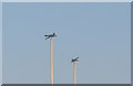
Rugby Post Foxes, Coal Pit Lane, Deepcar, near Sheffield
For an explanation of the Foxes ... see ...
Image
Image: © Terry Robinson
Taken: 20 Apr 2013
0.12 miles
3
Rugby Posts, Coal Pit Lane, Deepcar, near Sheffield
Stocksbridge Rugby Union Club play at this site ... and like Llanelli with their famous Saucepans ... the club has added their Fox Logo to the top of the posts.
Why a Fox ... well ... Samuel Fox was the founder of the Steel Works in Stocksbridge, making a fortune out of Steel Wire used in Umbrellas
For a closer view of the Foxes ... see ...
Image
Bolsterstone Village Church is visible in the background ... for a closer view of this lovely Church ... see ...
Image
Image: © Terry Robinson
Taken: 20 Apr 2013
0.12 miles
4
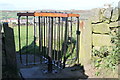
'New' gates
One of the recently revamped 'kissing gates' en route from Bolsterstone to Stocksbridge.
Image: © Dave Pickersgill
Taken: 8 Oct 2013
0.15 miles
5
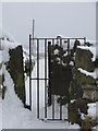
Gate in the snow
Gate on the path from Bolsterstone to Stocksbridge. This photograph was taken about 14:30 on Christmas Eve 2009.
Image: © Dave Pickersgill
Taken: 24 Dec 2009
0.15 miles
6
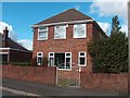
House on Hollin Busk Lane, Stocksbridge
Image: © Neil Theasby
Taken: 7 Oct 2011
0.15 miles
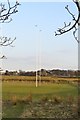
7
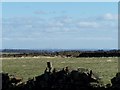
Distant view of Power Stations from Bolsterstone
Image: © Terry Robinson
Taken: 21 Mar 2008
0.16 miles
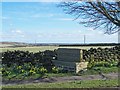
8
Stone Moor
Looking down the road at the edge of Stone Moor towards Hollin Busk.
Image: © Roger May
Taken: 15 Feb 2006
0.18 miles
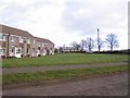
9
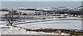
View from Walder's Low
The view from Walder's Low in a NW direction. In the foreground can be seen the ground of Stocksbridge RUFC. The mid-distance shows Whitwell estate and the hills towards Penistone are in the distance.
Image: © Dave Pickersgill
Taken: 28 Dec 2014
0.18 miles
10
Bolsterstone Village Sign
View from Stone Moor Road, with Power Stations in the distance.
Image: © Terry Robinson
Taken: 21 Mar 2008
0.21 miles