IMAGES TAKEN NEAR TO
Delph Mews, SHEFFIELD, S35 7EQ
Introduction
This page details the photographs taken nearby to Delph Mews, S35 7EQ by members of the Geograph project.
The Geograph project started in 2005 with the aim of publishing, organising and preserving representative images for every square kilometre of Great Britain, Ireland and the Isle of Man.

There are currently over 7.5m images from over14,400 individuals and you can help contribute to the project by visiting https://www.geograph.org.uk
Image Map
Images are licensed for reuse under creativecommons.org/licenses/by-sa/2.0
Notes
- Clicking on the map will re-center to the selected point.
- The higher the marker number, the further away the image location is from the centre of the postcode.
Image Listing (50 Images Found)
Images are licensed for reuse under creativecommons.org/licenses/by-sa/2.0
Image
Details
Distance
1
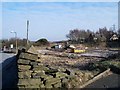
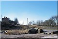
Rock and Ruin, Green Moor, near Wortley
Earlier photographs - see the links below - suggest that The Rock at Green Moor 'looks closed'. This picture confirms that, not only is it closed but it has now been demolished with the land up for sale. See Image ... Image ... Image
Image: © Terry Robinson
Taken: 8 Mar 2010
0.02 miles
2
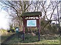
Village Information Board, Green Moor, near Wortley
Image: © Terry Robinson
Taken: 8 Mar 2010
0.02 miles
3
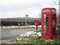
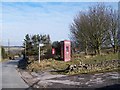
Green Moor
Just by the local public house is this grouping of Geograph-ical categories. The stocks against the drystone wall are posted in a supplemental image. The phonebox and postbox are well maintained and add a touch of colour to the scene. The stocks were moved to their present location from elsewhere at the time of the coronation of King George VI.
Image: © Roger May
Taken: 25 Feb 2006
0.03 miles
4
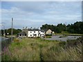
The Rock at Green Moor
Unfortunately the Rock now appears to be closed. After looking at the 1855 OS map I wonder if the original pub served the community of quarry men who worked the Green Moor Delf quarry as there were very few houses in the hamlet at this date.
Image: © Wendy North
Taken: 6 Aug 2008
0.03 miles
5
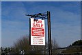
Rock For Sale, Green Moor, near Wortley
Not quite The Rock, but the land on which it stood! A novel use for the Pub Sign ... could you describe it as re-cycling? Image
Image: © Terry Robinson
Taken: 8 Mar 2010
0.04 miles
6
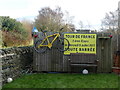
Tour de France souvenirs
In the garden of a house in Green Moor. The 2014 Tour de France started in Yorkshire ('Le Grand Départ') and passed through Midhopestones, a few miles to the west of here. The yellow bike was possibly one of the many placed on and near the route at the time, though the sign must have come from the event in France the following year.
Image: © Graham Hogg
Taken: 21 Mar 2016
0.04 miles
7
Village Centre, Green Moor, near Wortley
Green Moor Road runs off down the hill towards Wortley.
Image: © Terry Robinson
Taken: 8 Mar 2010
0.05 miles
8
Community Building, Green Moor, near Wortley
The small building, by the entrance to the (former) pub car park actually belongs to the Green Moor community and is one of their Heritage Buildings. During the demolition of The Rock Pub it has been secured against the demolishers inadvertently destroying it ... see ... Image
Image: © Terry Robinson
Taken: 8 Mar 2010
0.05 miles
9

'Hands Off' at Green Moor, near Wortley
This Community Building has been secured from the workers demolishing The Rock, the former village pub. See also ... Image
Image: © Terry Robinson
Taken: 8 Mar 2010
0.05 miles
10
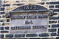
Green Moor School Sign, Green Moor, near Wortley
Image: © Terry Robinson
Taken: 8 Mar 2010
0.05 miles