IMAGES TAKEN NEAR TO
Cliffe Common Lane, SHEFFIELD, S35 7DU
Introduction
This page details the photographs taken nearby to Cliffe Common Lane, S35 7DU by members of the Geograph project.
The Geograph project started in 2005 with the aim of publishing, organising and preserving representative images for every square kilometre of Great Britain, Ireland and the Isle of Man.

There are currently over 7.5m images from over14,400 individuals and you can help contribute to the project by visiting https://www.geograph.org.uk
Image Map
Images are licensed for reuse under creativecommons.org/licenses/by-sa/2.0
Notes
- Clicking on the map will re-center to the selected point.
- The higher the marker number, the further away the image location is from the centre of the postcode.
Image Listing (7 Images Found)
Images are licensed for reuse under creativecommons.org/licenses/by-sa/2.0
Image
Details
Distance
1
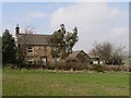
Cliffe Farm House
View from the footpath to Hermit Hill.
Image: © Wendy North
Taken: 15 Apr 2006
0.02 miles
2
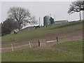
View across the horse paddock towards Cliffe Farm
Land from the farm is now divided up into small horse paddocks. The grain storage silo from the farm is the most dominant feature of the view.
Image: © Wendy North
Taken: 15 Apr 2006
0.03 miles
3
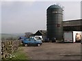
Silo and farm buildings at Cliffe Farm
Car parking area and farm buildings at Cliffe Farm.
Image: © Wendy North
Taken: 15 Apr 2006
0.03 miles
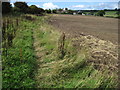
4
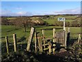
Footpath stile leading to Cliffe Farm
Image: © Stephen Ostler
Taken: 12 Jan 2020
0.05 miles
6
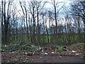
Lay-by and pull in for farm track Cliffe Common Road
Image: © Steve Fareham
Taken: 23 Dec 2008
0.24 miles
7
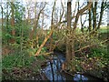
Gudgeon Hole Lane Stream
The smell of wild garlic and bluebells abound.
Image: © Steve Fareham
Taken: 6 May 2008
0.25 miles