IMAGES TAKEN NEAR TO
Crane Moor Nook, SHEFFIELD, S35 7AN
Introduction
This page details the photographs taken nearby to Crane Moor Nook, S35 7AN by members of the Geograph project.
The Geograph project started in 2005 with the aim of publishing, organising and preserving representative images for every square kilometre of Great Britain, Ireland and the Isle of Man.

There are currently over 7.5m images from over14,400 individuals and you can help contribute to the project by visiting https://www.geograph.org.uk
Image Map
Images are licensed for reuse under creativecommons.org/licenses/by-sa/2.0
Notes
- Clicking on the map will re-center to the selected point.
- The higher the marker number, the further away the image location is from the centre of the postcode.
Image Listing (9 Images Found)
Images are licensed for reuse under creativecommons.org/licenses/by-sa/2.0
Image
Details
Distance
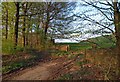
1
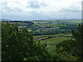
View towards Crane Moor Nook and Greenmoor
View over fields from the top of the tower at Stainborough Castle. The telecommunication tower can be seen at Green Moor and beyond that the open Pennine moorland.
Image: © Wendy North
Taken: 12 Jul 2008
0.02 miles
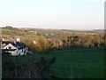
2
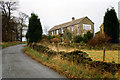
Houses on Crane Moor Road
Crane Moor Road leads from the A629 down to Crane Moor village. These houses are located a couple of hundred yards from the junction. Photo looking SW towards the junction.
Image: © Tony Teperek
Taken: Unknown
0.07 miles
5
Evening light on a gate into Farmland
On the road to Crane Moor from near the A629 road. I'm not sure what the red brick building behind the trees was?
Image: © Steve Fareham
Taken: 6 May 2008
0.20 miles
6

At Crane Moor Top
Evening arrives early in December. A flock of birds play follow-my-leader as they seek a roost for the long, cold night ahead.
Image: © Neil Theasby
Taken: 4 Dec 2013
0.21 miles
7
Cottages Crane Moor Road
Looking towards Crane Moor Bottom with Ayton Wood on the right.
Image: © Wendy North
Taken: 13 Nov 2005
0.23 miles
8
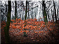
Beech leaves, Mill-Moor Heights
Woodland that stretches from the corner of Crane Moor Road almost into Wortley village.
Image: © Wendy North
Taken: 15 Jan 2012
0.23 miles
9
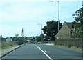
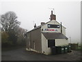
A629 Halifax Road at Thurgoland village boundary
Image: © Colin Pyle
Taken: 1 Jul 2018
0.25 miles