IMAGES TAKEN NEAR TO
Sheffield Road, SHEFFIELD, S35 4JB
Introduction
This page details the photographs taken nearby to Sheffield Road, S35 4JB by members of the Geograph project.
The Geograph project started in 2005 with the aim of publishing, organising and preserving representative images for every square kilometre of Great Britain, Ireland and the Isle of Man.

There are currently over 7.5m images from over14,400 individuals and you can help contribute to the project by visiting https://www.geograph.org.uk
Image Map
Images are licensed for reuse under creativecommons.org/licenses/by-sa/2.0
Notes
- Clicking on the map will re-center to the selected point.
- The higher the marker number, the further away the image location is from the centre of the postcode.
Image Listing (10 Images Found)
Images are licensed for reuse under creativecommons.org/licenses/by-sa/2.0
Image
Details
Distance
1
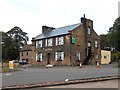
"The Crown" at the junction of the A61 and A629
Image: © Neil Theasby
Taken: 26 Sep 2011
0.02 miles
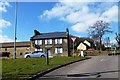
3
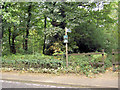
A61 Junction with A629
The signpost says Wortley 2 miles
Image: © John Fielding
Taken: 2 Apr 2007
0.06 miles
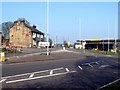
4
Footpath Skirting Hall Wood
This picture was taken from a position close to the A61/A629 junction.
Image: © Jonathan Clitheroe
Taken: 27 Sep 2011
0.09 miles
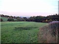
5
Footpath from A61 into Low Hall wood.
Image: © Steve Fareham
Taken: 18 Sep 2007
0.11 miles
7
Water Tower, Potter Hill, High Green - 2
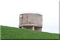
The grass bank in the foreground is named as 'Sunny Bank' on the 1905 OS Map. See also ... Image Image
Image: © Terry Robinson
Taken: 14 Apr 2010
0.21 miles
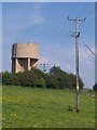
8
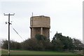
Potter Hill Water Tower, from Woodhead Road, near Grenoside
Image: © Terry Robinson
Taken: 11 Apr 2010
0.21 miles
9
Water Tower, Potter Hill, High Green - 3
Image: © Terry Robinson
Taken: 14 Apr 2010
0.21 miles
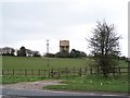
10
Water Tower, Potter Hill, High Green - 1
From this view - by the entrance gate to the Reservoir and Tower site - the grass bank of the Water Reservoir disguises the height of the Water Tower. The Water Works site - but not the Tower - is shown on the 1905 OS map of the area ... at that date belonging to the Wortley Rural District Council. For a view which shows the full height of the Tower, see ... Image ... See also Image Image Image
Image: © Terry Robinson
Taken: 14 Apr 2010
0.21 miles