IMAGES TAKEN NEAR TO
Astwell Gardens, SHEFFIELD, S35 2ZH
Introduction
This page details the photographs taken nearby to Astwell Gardens, S35 2ZH by members of the Geograph project.
The Geograph project started in 2005 with the aim of publishing, organising and preserving representative images for every square kilometre of Great Britain, Ireland and the Isle of Man.

There are currently over 7.5m images from over14,400 individuals and you can help contribute to the project by visiting https://www.geograph.org.uk
Image Map
Images are licensed for reuse under creativecommons.org/licenses/by-sa/2.0
Notes
- Clicking on the map will re-center to the selected point.
- The higher the marker number, the further away the image location is from the centre of the postcode.
Image Listing (17 Images Found)
Images are licensed for reuse under creativecommons.org/licenses/by-sa/2.0
Image
Details
Distance
1
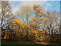
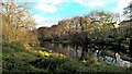
Autumn colour in Charlton Brook
Charlton Brook provides a ribbon of green space in the middle of a large housing development
Image: © Graham Hogg
Taken: 23 Nov 2020
0.16 miles
3
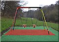
Forlorn swings in Charltonbrook Park
At High Green, Sheffield
Image: © Neil Theasby
Taken: 19 Dec 2012
0.19 miles
5
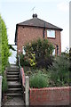
#41 Worrall Road
There is an OS benchmark Image on the corner of the house at the top of the steps
Image: © Roger Templeman
Taken: 21 Jun 2013
0.22 miles
6
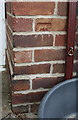
Benchmark on #41 Worrall Road
Ordnance Survey cut mark benchmark described on the Bench Mark Database at http://www.bench-marks.org.uk/bm49367
Image: © Roger Templeman
Taken: 21 Jun 2013
0.23 miles
7
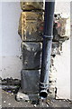
Benchmark on #319 Burncross Road
Ordnance Survey cut mark benchmark described on the Bench Mark Database at http://www.bench-marks.org.uk/bm49376
Image: © Roger Templeman
Taken: 21 Jun 2013
0.23 miles
8
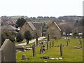
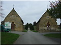
Charltonbrook Cemetery
Looking south from the heights of the cemetery, past the twin chapels at its entrance. Houses at Burncross stand on the adjacent hill.
Image: © Roger May
Taken: 13 Mar 2006
0.23 miles
9
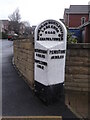
Old milestone
About ½ mile from the centre of Chapeltown on Burncross Road at Burncross Drive. This West Riding CC stone from 1893/94 is shown to the full height of the attachment. There will be another 20cm of stone under pavement level. All 4 fixing points can be seen. There is a hole in the top for previous use by Ordnance Survey. It was in front of a school building which was demolished, houses were built and the stone slightly repositioned. It is grade II listed 335445.
Image: © Chris Minto
Taken: 3 Mar 2019
0.24 miles