IMAGES TAKEN NEAR TO
Waterside Gardens, SHEFFIELD, S35 0JS
Introduction
This page details the photographs taken nearby to Waterside Gardens, S35 0JS by members of the Geograph project.
The Geograph project started in 2005 with the aim of publishing, organising and preserving representative images for every square kilometre of Great Britain, Ireland and the Isle of Man.

There are currently over 7.5m images from over14,400 individuals and you can help contribute to the project by visiting https://www.geograph.org.uk
Image Map
Images are licensed for reuse under creativecommons.org/licenses/by-sa/2.0
Notes
- Clicking on the map will re-center to the selected point.
- The higher the marker number, the further away the image location is from the centre of the postcode.
Image Listing (511 Images Found)
Images are licensed for reuse under creativecommons.org/licenses/by-sa/2.0
Image
Details
Distance
1
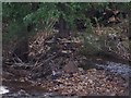
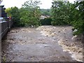
Debris caught amongst trees at Oughtibridge following floods in June 2007
Much debris, stones, trees, branches and general rubbish was swept down the River Don during the floods in June 2007. Wherever there were obstacles, Bridges, Weirs, Trees, etc., the debris was caught up and remained when the waters subsided. This pictures shows some of the debris caught up on the middle river island near to Oughtibridge bridge. This whole area has, in March 2008, been cleaned up by removing most of the Trees from the middle of the river course ... see other pictures showing this view.
Image: © Terry Robinson
Taken: 1 Jul 2007
0.01 miles
2

Oughtibridge Brass Band Hut, Station Lane, Oughtibridge - 2
Taken from the river bank. This building was formerly the village Telephone Exchange, replacing the original which was in Orchard Street.
See also ...
Image
Update in 2013 ... The Hut is finally being extended and modernised ... see ...
Image
Image
Image
Image: © Terry Robinson
Taken: 7 Mar 2008
0.01 miles
3
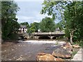
One - Nil to The Environment Agency at Oughtibridge
The River Don in September 2008, swollen by heavy rain, tests the new flood repair work at Oughtibridge ... and loses! Well done the Environment Agency.
Image: © Terry Robinson
Taken: 6 Sep 2008
0.01 miles
4
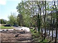
Riverside Parking, River Don, Oughtibridge
Following the devastating flooding in June 2007 ... the Riverside Path has finally been 'sorted' with some parking spaces now incorporated. A great improvement all round. Image Image
Image: © Terry Robinson
Taken: 22 Apr 2009
0.01 miles
5

Oughtibridge Brass Band Hut, Station Lane, Oughtibridge - 1
Taken from Station Lane. This building was formerly the village Telephone Exchange, replacing the original which was in Orchard Street.
See also ...
Image
Update in 2013 ... The Hut is finally being extended and modernised ... see ...
Image
Image
Image
Image: © Terry Robinson
Taken: 7 Mar 2008
0.02 miles
7
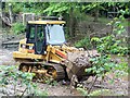
'Man and Machine at Work' ... River Don, Oughtibridge
Image: © Terry Robinson
Taken: 2 Jul 2008
0.02 miles
8
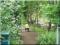
'Man at Rest' ... River Don, Oughtibridge
Image: © Terry Robinson
Taken: 2 Jul 2008
0.02 miles
9
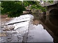
June 2007 - River Don Weir at Oughtibridge during the flood.
This picture shows the River Don, roaring over the bridge weir, at its highest during the flood of June 2007 Image Image
Image: © Terry Robinson
Taken: 25 Jun 2007
0.02 miles
10
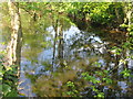
River Don
Reflections in the River Don, Oughtibridge, South Yorkshire.
Image: © Dave Pickersgill
Taken: 27 Apr 2011
0.03 miles