IMAGES TAKEN NEAR TO
Boggard Lane, SHEFFIELD, S35 0FJ
Introduction
This page details the photographs taken nearby to Boggard Lane, S35 0FJ by members of the Geograph project.
The Geograph project started in 2005 with the aim of publishing, organising and preserving representative images for every square kilometre of Great Britain, Ireland and the Isle of Man.

There are currently over 7.5m images from over14,400 individuals and you can help contribute to the project by visiting https://www.geograph.org.uk
Image Map
Images are licensed for reuse under creativecommons.org/licenses/by-sa/2.0
Notes
- Clicking on the map will re-center to the selected point.
- The higher the marker number, the further away the image location is from the centre of the postcode.
Image Listing (41 Images Found)
Images are licensed for reuse under creativecommons.org/licenses/by-sa/2.0
Image
Details
Distance
1
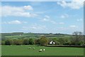
The Asplands, from Birtin Footpath, Worrall, Sheffield
The Asplands is the white house in the mid-ground. Jawbone Hill, above Oughtibridge, is visible, in the distance, from the footpath, but probably not from The Asplands!
Image: © Terry Robinson
Taken: 2 May 2009
0.02 miles
2
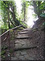
Footpath to Hagg Stones Quarry, Oughtibridge, Sheffield
This path runs from Boggard Lane down through Hagg Stones Quarry to Haggstones Road, Oughtibridge ... often used by the pupils from Bradfield School as a shortcut home ... certainly used by my wife in the late 60's / early 70's.
Image: © Terry Robinson
Taken: 2 May 2009
0.04 miles
3
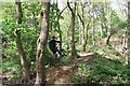
'Take Off' in Hagg Stones Quarry, Oughtibridge
Two lads, having fun on the cycle trails in Hagg Stones Quarry, happily performed their 'stunts' for me ... it took a few shots but I got this one just at 'take off point' ... thanks lads. Image
Image: © Terry Robinson
Taken: 2 May 2009
0.05 miles
4
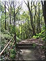
Footpath in Hagg Stones Quarry, Oughtibridge
Image: © Terry Robinson
Taken: 2 May 2009
0.06 miles
5
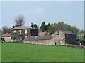
Quarry Farm, Worrall, near Oughtibridge
The stone quarry, from which this Farm got its name, was behind the buildings and down Boggard Lane, but has long gone. Image Image
Image: © Terry Robinson
Taken: 8 May 2008
0.06 miles
6
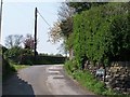
Boggard Lane, Worrall, near Oughtibridge
Boggard Lane - reportedly named after some 'mischievous evil imps' - runs from Worrall through to Burton Lane above Oughtibridge, but soon turns into a track rather than a road ... so don't try it in your car! On the left of Boggard Lane is Quarry Farm ... on the right would have been the quarry! Image Image Image Image
Image: © Terry Robinson
Taken: 8 May 2008
0.07 miles
7

'Fly Past' in Hagg Stones Quarry, Oughtibridge
Watch out ... there's a biker about! Image
Image: © Terry Robinson
Taken: 2 May 2009
0.08 miles
8
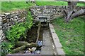
Tun Gate Well and Washing Trough
The Tun Gate Well and Washing Trough at Worrall is over 200 years old. In 2020 the trough was restored with funding from Sheffield Lakeland Landscape Partnership.
Image: © Dave Pickersgill
Taken: 12 May 2022
0.08 miles
9
Hagg Stones Footpath, Haggstones Road, Oughtibridge
This footpath leads up through (the former) Hagg Stones Quarry
to Boggard Lane ... and onwards to Worrall.
Used by the 'fitter' pupils from Bradfield School as a shortcut to and
from Oughtibridge. The ' non-fit' pupils use the School Bus!
Image: © Terry Robinson
Taken: 2 May 2009
0.10 miles
10
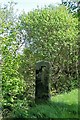
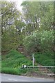
Stone Post, Boggard Lane, Oughtibridge
This big stone post has a square hole in it ... why? Your guess is as good as mine. There is no sign of a second so it doesn't seem to be a gatepost.
Image: © Terry Robinson
Taken: 2 May 2009
0.10 miles