IMAGES TAKEN NEAR TO
New Church Street, HOPE VALLEY, S33 9JN
Introduction
This page details the photographs taken nearby to New Church Street, S33 9JN by members of the Geograph project.
The Geograph project started in 2005 with the aim of publishing, organising and preserving representative images for every square kilometre of Great Britain, Ireland and the Isle of Man.

There are currently over 7.5m images from over14,400 individuals and you can help contribute to the project by visiting https://www.geograph.org.uk
Image Map
Images are licensed for reuse under creativecommons.org/licenses/by-sa/2.0
Notes
- Clicking on the map will re-center to the selected point.
- The higher the marker number, the further away the image location is from the centre of the postcode.
Image Listing (53 Images Found)
Images are licensed for reuse under creativecommons.org/licenses/by-sa/2.0
Image
Details
Distance
1
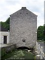
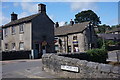
Soft Water Lane, Bradwell
An unusual place to site a building.
Image: © Martin Speck
Taken: 15 Jul 2008
0.02 miles
2
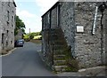
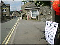
Street name sign, in need of attention
New Church Street, I think, Bradwell.
Image: © Peter Barr
Taken: 15 Jul 2011
0.02 miles
3
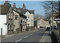
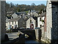
Church Street, Bradwell
The narrow section of the B6049 main road through the village is controlled by traffic lights. Viewpoint by the churchyard.
Image: © Andrew Hill
Taken: 29 Mar 2012
0.03 miles
5
Soft Water Lane, Bradwell
The Wesleyan Sunday School (1844).
Image: © Peter Barr
Taken: 3 Aug 2014
0.03 miles
6
Strawberry Fayre
Bradwell Infant School sign advertising their Strawberry Fayre. The sign is outside the Parish Church sign.
Image: © William Metcalfe
Taken: 14 Jul 2007
0.04 miles
7
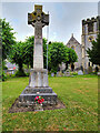
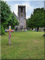
Bradwell War Memorial
The memorial stands in front of St Barnabas Church, facing the main road. It is in the form of a two-stepped base surmounted by a plinth and wheel cross.
https://www.roll-of-honour.com/Derbyshire/BradwellStBarnabas.html more information and names of the fallen.
Image: © David Dixon
Taken: 1 Jul 2023
0.04 miles
8
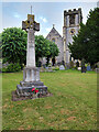
Bradwell War Memorial and St Barnabas' Church
The memorial stands in front of St Barnabas Church, facing the main road. It is in the form of a two-stepped base surmounted by a plinth and wheel cross https://www.roll-of-honour.com/Derbyshire/BradwellStBarnabas.html (more information and names of the fallen).
The church was built 1867-8 with the tower added 1888-91. It is a Grade II listed building (List Entry Number:1087832 https://historicengland.org.uk/listing/the-list/list-entry/1087832?section=official-list-entry Historic England).
Image: © David Dixon
Taken: 1 Jul 2023
0.04 miles
9
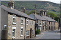
Village scene by the stream, Bradwell
The village is set on hillsides with a stream running through.
Image: © Andrew Hill
Taken: 29 Mar 2012
0.05 miles
10
The Parish Church of St Barnabas, Bradwell
Church built 1867-8 with the tower added 1888-91. Grade II listed building (List Entry Number:1087832 https://historicengland.org.uk/listing/the-list/list-entry/1087832?section=official-list-entry Historic England).
Image: © David Dixon
Taken: 1 Jul 2023
0.05 miles