IMAGES TAKEN NEAR TO
Castleton Road, HOPE VALLEY, S33 8RZ
Introduction
This page details the photographs taken nearby to Castleton Road, S33 8RZ by members of the Geograph project.
The Geograph project started in 2005 with the aim of publishing, organising and preserving representative images for every square kilometre of Great Britain, Ireland and the Isle of Man.

There are currently over 7.5m images from over14,400 individuals and you can help contribute to the project by visiting https://www.geograph.org.uk
Image Map
Images are licensed for reuse under creativecommons.org/licenses/by-sa/2.0
Notes
- Clicking on the map will re-center to the selected point.
- The higher the marker number, the further away the image location is from the centre of the postcode.
Image Listing (9 Images Found)
Images are licensed for reuse under creativecommons.org/licenses/by-sa/2.0
Image
Details
Distance
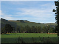
1
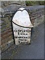
Old Milepost by the A625, Castleford Road, west of Hope
Cast iron post by the A625, in parish of HOPE (HIGH PEAK District), Castleton Road, Veintutt Villas, East of Marston Farm, Losehill Hall, in tarmac path in front of low stone wall, on South side of road. Heart scroll iron casting, erected by the Sheffield & Chapel en le Frith turnpike trust in the 19th century.
Inscription reads:-
: CASTLETON / 1 MILE / CHAPEL EN LE / FRITH / 7 MILES : : SHEFFIELD / 15 MILES / HATHERSAGE / 5 MILES :
Grade II Listed. List Entry Number:1096623
https://historicengland.org.uk/listing/the-list/list-entry/1096623
Milestone Society National ID: DE_SFCH15.
Image: © J Higgins
Taken: 1 May 2002
0.01 miles
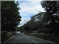
2
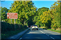
High Peak : Castleton Road A6187
A road between Hope and Castleton.
Image: © Lewis Clarke
Taken: 1 Oct 2018
0.03 miles
3
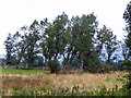
Old Poplar Plantation
These rather decrepit poplars surround a circular reservoir next to Peakhole Water. Presumably the site was once part of the local area water works. Looking at old maps it looks as if they were planted post WWII.
Image: © SK53
Taken: 14 Sep 2014
0.19 miles
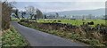
4
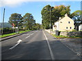
Castleton Road near Marsh Farm
This photograph shows a view of a section of Castleton Road near Marsh Farm. The picture was taken looking in a west-south-westerly direction towards Marston Farm.
Image: © Philip Barker
Taken: 11 Oct 2010
0.20 miles
5
Poplars around Sewage Farm in Hope Valley
Seen from the Castleton-Hope road
Image: © SK53
Taken: 11 Sep 2016
0.20 miles
6
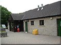
Facilities Block, Losehill Caravan Club Site
All mod cons at Losehill CC Site, Castleton.
Image: © Paul Shreeve
Taken: 19 Jun 2008
0.22 miles
7
Castleton Road near the entrance to Losehill Hall
Image: © Steve Fareham
Taken: 16 Jul 2014
0.23 miles
8
Warehouse Lane, Hope
Hope Valley Cement works in background
Image: © Chris Morgan
Taken: 30 Dec 2020
0.23 miles
9
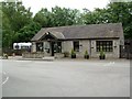
Losehill Caravan Club Site, Castleton
This is the office at Losehill Caravan Club Site at Castleton, High Peak
Image: © Paul Shreeve
Taken: 19 Jun 2008
0.24 miles