IMAGES TAKEN NEAR TO
Hathersage Road, HOPE VALLEY, S33 0EB
Introduction
This page details the photographs taken nearby to Hathersage Road, S33 0EB by members of the Geograph project.
The Geograph project started in 2005 with the aim of publishing, organising and preserving representative images for every square kilometre of Great Britain, Ireland and the Isle of Man.

There are currently over 7.5m images from over14,400 individuals and you can help contribute to the project by visiting https://www.geograph.org.uk
Image Map
Images are licensed for reuse under creativecommons.org/licenses/by-sa/2.0
Notes
- Clicking on the map will re-center to the selected point.
- The higher the marker number, the further away the image location is from the centre of the postcode.
Image Listing (107 Images Found)
Images are licensed for reuse under creativecommons.org/licenses/by-sa/2.0
Image
Details
Distance
1
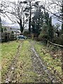
Muddy Track
The footpath is rather muddy being part of the vehicle access to the grass field.
Image: © Jay Pea
Taken: 1 Mar 2024
0.06 miles
2
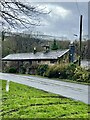
Bridge House
Bridge House in winter, formerly several cottages, housing a post office and smithy.
Image: © Jay Pea
Taken: 1 Mar 2024
0.06 miles
3
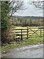
Field Footpath
The stile and footpath leading to Station Road.
Image: © Jay Pea
Taken: 1 Mar 2024
0.07 miles
4
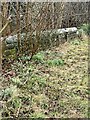
Overgrown pavement
The old pavement on Mytham Lane. no longer used and overgrown with garden flower escapees.
Image: © Jay Pea
Taken: 1 Mar 2024
0.07 miles
5
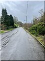
Mytham Lane
The old road blocked off adjacent to the river bridge, now providing access to a few houses and unofficial car park to the local footpaths.
Image: © Jay Pea
Taken: 1 Mar 2024
0.07 miles
6
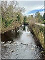
River Derwent
The River Derwent near Bamford.
Image: © Jay Pea
Taken: 1 Mar 2024
0.07 miles
7
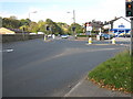
Road Junction at Stickleholme
This photograph shows a view of the road junction formed by the intersection of the A6187 road (on the left) and the A6013 road (on the right). Stickleholm service station can be seen in the right-hand side of the image. The picture was taken looking in a west-north-westerly direction towards Shatton.
Image: © Philip Barker
Taken: 11 Oct 2010
0.09 miles
8
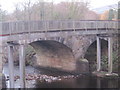
Mytham Bridge
Showing both road and foot bridges.
Image: © Peter Wood
Taken: 21 Nov 2012
0.09 miles
9
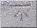
Ordnance Survey Cut Mark
This mark can be found on the parapet of Mytham Bridge.
For more detail see : http://www.bench-marks.org.uk/bm46296
Image: © Peter Wood
Taken: 21 Nov 2012
0.09 miles
10
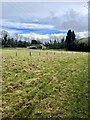
Field and Bungalow
A field and bungalow alongside Mytham Lane.
Image: © Jay Pea
Taken: 1 Mar 2024
0.10 miles