IMAGES TAKEN NEAR TO
The Dale, HOPE VALLEY, S32 4TE
Introduction
This page details the photographs taken nearby to The Dale, S32 4TE by members of the Geograph project.
The Geograph project started in 2005 with the aim of publishing, organising and preserving representative images for every square kilometre of Great Britain, Ireland and the Isle of Man.

There are currently over 7.5m images from over14,400 individuals and you can help contribute to the project by visiting https://www.geograph.org.uk
Image Map
Images are licensed for reuse under creativecommons.org/licenses/by-sa/2.0
Notes
- Clicking on the map will re-center to the selected point.
- The higher the marker number, the further away the image location is from the centre of the postcode.
Image Listing (176 Images Found)
Images are licensed for reuse under creativecommons.org/licenses/by-sa/2.0
Image
Details
Distance
1
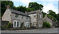
Stone-built Houses
The stonework is typical of the buildings in the Peak District. These houses are right beside the A 623 as it runs through Stoney Middleton.
Image: © Anne Burgess
Taken: 25 Jun 2014
0.00 miles
2
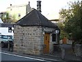
Stoney Middleton, former tollhouse
On The Bank (A623), former tollhouse built 1840, now "Toll Bar Fish and Chips"; listed by English Heritage http://www.imagesofengland.org.uk/Details/Default.aspx?id=80706&mode=quick
Image: © Mike Faherty
Taken: 14 Jan 2011
0.02 miles
3
Fish and chip shop, Stoney Middleton
Unusually located in an octagonal Toll House which was built late in 1840 to collect dues from travellers on the new turnpike road
Image: © Graham Hogg
Taken: 27 Oct 2010
0.02 miles
4
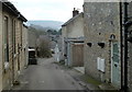
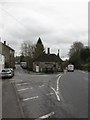
Bottom Cliff, Stoney Middleton
Looking down the hill into the village. The houses on the right are near the cliff edge above the valley carrying the main road.
Image: © Andrew Hill
Taken: 16 Feb 2012
0.02 miles
5
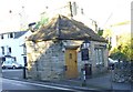
Old Toll House by the A623, Stoney Middleton
Toll House by the A623, in the parish of Stoney Middleton (Derbyshire Dales District), Toll House Fish and Chip Shop, The Avenue, S32 4TB.
Grade II listed.
List Entry Number: 1110003 https://historicengland.org.uk/listing/the-list/list-entry/1110003
Surveyed
Milestone Society National ID: DE.STO
Image: © Alan Rosevear
Taken: 10 Nov 2013
0.02 miles
6
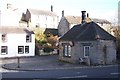
Stoney Middleton chip shop
Standing next to the A623 it was a former toll booth.
Image: © Phil Berry
Taken: 12 Dec 2005
0.02 miles
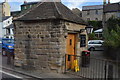
7
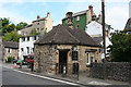
Toll House
This little sandstone building is instantly recognisable as a toll house because of the windows placed at 45º to the road, so that the tollkeeper could easily see approaching traffic. It is now a fish and chip shop.
Image: © Anne Burgess
Taken: 25 Jun 2014
0.02 miles
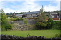
8
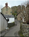
Bottom Cliff, Stoney Middleton
Looking up the hill. The houses on the left are perched above the valley cliffs.
Image: © Andrew Hill
Taken: 16 Feb 2012
0.02 miles