IMAGES TAKEN NEAR TO
Riddings Lane, HOPE VALLEY, S32 3YN
Introduction
This page details the photographs taken nearby to Riddings Lane, S32 3YN by members of the Geograph project.
The Geograph project started in 2005 with the aim of publishing, organising and preserving representative images for every square kilometre of Great Britain, Ireland and the Isle of Man.

There are currently over 7.5m images from over14,400 individuals and you can help contribute to the project by visiting https://www.geograph.org.uk
Image Map
Images are licensed for reuse under creativecommons.org/licenses/by-sa/2.0
Notes
- Clicking on the map will re-center to the selected point.
- The higher the marker number, the further away the image location is from the centre of the postcode.
Image Listing (39 Images Found)
Images are licensed for reuse under creativecommons.org/licenses/by-sa/2.0
Image
Details
Distance
1
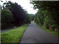
Lane Junction to the North of Curbar
3 lanes are visible here. Riddings Lane towards Froggatt is straight ahead, Dukes Drive is to the right and the lane from where the picture is taken - known as 'The Bent'.
Image: © Jonathan Clitheroe
Taken: 6 Jul 2011
0.08 miles
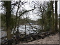
3
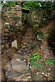
Tributary inlet
These 'steps' take water from a drainage ditch down to the river Derwent.
Image: © Roger Temple
Taken: 15 Sep 2007
0.11 miles
4
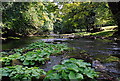
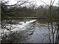
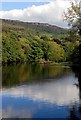
The river Derwent near Calver
Taken from just south-east of the weir, this picture shows the river looking downstream.
Image: © Roger Temple
Taken: 15 Sep 2007
0.11 miles
5
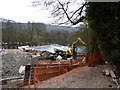
Calver Weir; masonry
The repairs to the 19th century weir involve the replacement of damaged blocks of masonry with similar local stone.
See Image
Image: © Peter Barr
Taken: 26 Jan 2010
0.12 miles
6
Calver Weir
Taken from a promontory on the river below the weir.
Image: © Andy Stephenson
Taken: 1 Nov 2011
0.15 miles
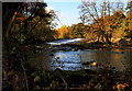
7
Below the weir
A weir dams the river Derwent at this point which used to feed water to Calver Mill. Below the weir the river is wider and shallower with several small islands.
Image: © Roger Temple
Taken: 15 Sep 2007
0.15 miles
8
Calver Weir; repair work machinery
The small dumper truck is driven across the flat crest
Image: © Peter Barr
Taken: 26 Jan 2010
0.15 miles
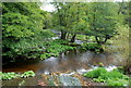
9
River Derwent above the weir
Looking south-east from the bridge where the B6054 crosses the river Derwent. In the background is Baslow Edge.
Image: © Roger Temple
Taken: 15 Sep 2007
0.15 miles