IMAGES TAKEN NEAR TO
Winney Lane, SHEFFIELD, S26 7YP
Introduction
This page details the photographs taken nearby to Winney Lane, S26 7YP by members of the Geograph project.
The Geograph project started in 2005 with the aim of publishing, organising and preserving representative images for every square kilometre of Great Britain, Ireland and the Isle of Man.

There are currently over 7.5m images from over14,400 individuals and you can help contribute to the project by visiting https://www.geograph.org.uk
Image Map (Loading...)


Getting Data...Please wait
Leaflet Map data © OpenStreetMap
Images are licensed for reuse under creativecommons.org/licenses/by-sa/2.0
Notes
- Clicking on the map will re-center to the selected point.
- The higher the marker number, the further away the image location is from the centre of the postcode.
Image Listing (8 Images Found)
Images are licensed for reuse under creativecommons.org/licenses/by-sa/2.0
Image
Details
Distance
1
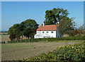
Carr Farm Cottage
By Winney Lane south of the village of Harthill.
Image: © Andrew Hill
Taken: 28 Sep 2011
0.01 miles
3
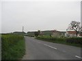
Fields and the course of a small stream
Viewpoint is Winney Lane just south of Carr Farm cottage.
Image: © Andrew Hill
Taken: 28 Sep 2011
0.07 miles
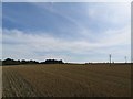
4
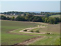
Open fields west of Winney Lane
The ground descends gently from the lane, with wide views.
Image: © Andrew Hill
Taken: 28 Sep 2011
0.08 miles
5

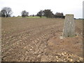
Triangulation pillar south of Harthill (Fir Hill)
Unique Waypoint POI Name: 0157
Image: © Neil Theasby
Taken: 29 Aug 2014
0.20 miles
6
Fir Hill - Harthill Field
Bagged the trig first then very easy access from cultivated field to south side of reservoir complex. Rotherham current county/UA top.
Name: Fir Hill - Harthill Field
Hill number: 5534
Height: 157m / 515ft
Area: 37: The River Tees to The Wash
Class: CoU
Grid ref: SK 49447 79700
Summit feature: no feature: unmarked spot height by covered reservoir
Drop: 23m
Col: 134m SK497782
Image: © Rude Health
Taken: 30 Jan 2011
0.21 miles
8
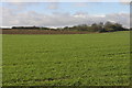
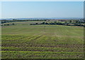
Fields and Water
The building to the left of the horizon is an underground water reservoir.
Image: © Michael Patterson
Taken: 14 Feb 2006
0.25 miles