IMAGES TAKEN NEAR TO
Jackys Lane, SHEFFIELD, S26 7XU
Introduction
This page details the photographs taken nearby to Jackys Lane, S26 7XU by members of the Geograph project.
The Geograph project started in 2005 with the aim of publishing, organising and preserving representative images for every square kilometre of Great Britain, Ireland and the Isle of Man.

There are currently over 7.5m images from over14,400 individuals and you can help contribute to the project by visiting https://www.geograph.org.uk
Image Map
Images are licensed for reuse under creativecommons.org/licenses/by-sa/2.0
Notes
- Clicking on the map will re-center to the selected point.
- The higher the marker number, the further away the image location is from the centre of the postcode.
Image Listing (63 Images Found)
Images are licensed for reuse under creativecommons.org/licenses/by-sa/2.0
Image
Details
Distance
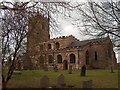
1
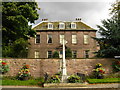
The Old Rectory, Harthill
This is a view of The Old Rectory situated on Union Street. It was rebuilt around 1720 for the 2nd Reverend John Hewitt. In front of the rectory wall is the village War Memorial.
Image: © Bobby Clegg
Taken: 17 Oct 2008
0.06 miles
3
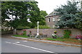
War memorial, Union Street, Harthill
For history of the village http://www.harthill-village.co.uk/
Image: © Tim Heaton
Taken: 5 Oct 2013
0.08 miles
4

Harthill War Memorial
War memorial by All Hallows church
Image: © Richard Croft
Taken: 1 Jun 2009
0.08 miles
5

The Old Rectory
Rebuilt c1720 for the second Rev.John Hewitt
Image: © Richard Croft
Taken: 1 Jun 2009
0.08 miles
6
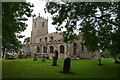
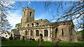
Church of All Hallows, Harthill
First built in 1085 by William de Warrene, the Conqueror's son-in-law. Enlarged in the 12th and 16th and restored in the 19th century.
Image: © Tim Heaton
Taken: 5 Oct 2013
0.10 miles
8
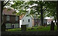
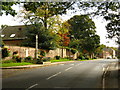
Houses across the churchyard, Harthill
Looking across the corner of the churchyard to houses on Union Street, the main road through the village. The 1:25,000 map puts the church firmly within the square.
Image: © Andrew Hill
Taken: 2 Sep 2010
0.10 miles
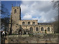
9
All Hallows - Harthill's parish church
Image: © Neil Theasby
Taken: 15 Feb 2012
0.10 miles