IMAGES TAKEN NEAR TO
Stone Close, SHEFFIELD, S26 6SQ
Introduction
This page details the photographs taken nearby to Stone Close, S26 6SQ by members of the Geograph project.
The Geograph project started in 2005 with the aim of publishing, organising and preserving representative images for every square kilometre of Great Britain, Ireland and the Isle of Man.

There are currently over 7.5m images from over14,400 individuals and you can help contribute to the project by visiting https://www.geograph.org.uk
Image Map
Images are licensed for reuse under creativecommons.org/licenses/by-sa/2.0
Notes
- Clicking on the map will re-center to the selected point.
- The higher the marker number, the further away the image location is from the centre of the postcode.
Image Listing (28 Images Found)
Images are licensed for reuse under creativecommons.org/licenses/by-sa/2.0
Image
Details
Distance
1
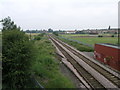
Siding to Nowhere
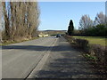
The old siding off the Worksop to Sheffield line used to serve the former Kiveton Park Colliery which occupied the area behind the hedge on the left.
Image: © Michael Patterson
Taken: 4 Jul 2006
0.13 miles
2
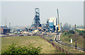
Demolishing Kiveton Park Colliery 1995
The colliery closed in 1994 and the main shaft buildings were demolished a year later. However, the mine's pithead baths were deemed to be of historical value and had a listed building order placed on them. But they never opened to public view and due to vandalism they were eventually demolished in 2013. The whole site has been landscaped and fishing ponds were added. The Norwood canal tunnel of the Chesterfield Canal passes close beneath and it has been proposed to untop the tunnel here and substitute a flight of locks in its place. But, as yet, nothing has materialised due to local problems and the inevitable cash shortage. In the photograph can be seen the huge electric winding apparatus.
Image: © Richard Bird
Taken: 19 Apr 1995
0.16 miles
3

The Saxon Hotel, Kiveton Park
A Sam Smith's public house.
Image: © Ian S
Taken: 12 Aug 2012
0.18 miles
4
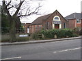
Kiveton Park - St. Augustine's Catholic Church
Image: © Alan Heardman
Taken: 27 Jan 2009
0.19 miles
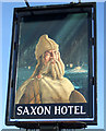
7
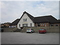
The Saxon Hotel, Kiveton Park
A Sam Smith's public house.
Image: © Ian S
Taken: 12 Aug 2012
0.19 miles
8
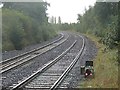
Shunting Signal at Kiveton Bridge Station
Kiveton Park, South Yorkshire.
Not many years ago, this view from the end of Platform 2 at Kiveton Bridge station would have been a very different scene. The line of trees on the right would not have existed and straight ahead we would have been looking directly at Kiveton Park Colliery, which would have then dominated this scene. Just beyond the still extant ground position light in the foreground would have been points leading to sidings in the pit yard, and from this vantage point we would have had a clear view of wagons being loaded with coal.
The pit closed in 1994 and the whole area it occupied, including the pit tip, has since been transformed into the mini country park we know today as Kiveton Community Woodland. The sidings within the pit yard would have been lifted soon after the pit's closure, although the points on the main running line remained for some time afterwards. However, they too have now gone, and yet the redundant ground shunting signal remains to this day and, as can be seen from this picture, is still illuminated.
Image: © Mike Nield
Taken: 30 Sep 2017
0.19 miles
9
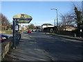
Bus stop and shelter on Station Road, Kiveton Park
Outside the Saxon Hotel public house.
Image: © JThomas
Taken: 7 Mar 2015
0.19 miles
10
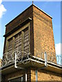
Kiveton Park Colliery
A view of the boarded up & razor wired brick tower of the former pithead baths.
Image: © Bobby Clegg
Taken: 17 Oct 2008
0.19 miles