IMAGES TAKEN NEAR TO
Hard Lane, SHEFFIELD, S26 6RP
Introduction
This page details the photographs taken nearby to Hard Lane, S26 6RP by members of the Geograph project.
The Geograph project started in 2005 with the aim of publishing, organising and preserving representative images for every square kilometre of Great Britain, Ireland and the Isle of Man.

There are currently over 7.5m images from over14,400 individuals and you can help contribute to the project by visiting https://www.geograph.org.uk
Image Map (Loading...)


Getting Data...Please wait
Leaflet Map data © OpenStreetMap
Images are licensed for reuse under creativecommons.org/licenses/by-sa/2.0
Notes
- Clicking on the map will re-center to the selected point.
- The higher the marker number, the further away the image location is from the centre of the postcode.
Image Listing (16 Images Found)
Images are licensed for reuse under creativecommons.org/licenses/by-sa/2.0
Image
Details
Distance
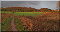
2
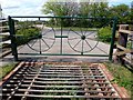
Fence and cattle grid
An unusual piece of fencing guards the cattle grid. The Cuckoo Way crosses Hard Lane here.
Image: © Graham Hogg
Taken: 30 Apr 2012
0.08 miles
3
Tommy Flockton?s from Hard Lane
Kiveton Park, South Yorkshire
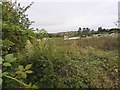
Pennyholme Marsh, better known to locals as “Tommy Flockton's”, is an area of low-lying wetland straddled between the Norwood Tunnel on the Chesterfield Canal and the Sheffield to Lincoln railway line to the east of the village of Kiveton Park in South Yorkshire; Tommy Flockton being a local farmer who once owned the land (circa 1833). The lower, central part of the marsh floods extensively in winter, but the surrounding higher ground remains dry and is grazed by many horses, said to be the descendants of the old pit ponies that once worked down Kiveton Park Colliery which, until its closure in 1994, stood across the road on the west side of Hard Lane.
Lying to the east of Hard Lane, a public footpath passes over the marsh to join up with the Chesterfield Canal by the eastern portal of the Norwood Tunnel. This path is part of the Cuckoo Way, a 46-mile Long Distance Path following the route of the canal from Chesterfield to West Stockwith where the canal joins the River Trent. The tunnel itself passes beneath the marsh, its line marked by a succession of spoil mounds from the construction shafts. It was here where the tunnel collapsed in October 1907 forcing its closure.
The marsh is also crossed on its northern side by the Broad Bridge Dyke, which takes its water from nearby Pebley and Harthill Reservoirs to feed the Chesterfield Canal. It flows for approximately two miles before finally emptying into the canal via a spectacular cascade https://www.geograph.org.uk/photo/6248502 near Kiveton Park Station.
During the mid-1980s, four local folk musicians formed a band under the name “Tommy Flockton’s” and even had their own signature tune which was named after them. It can be heard here https://www.flickr.com/photos/128783627@N03/24493661149/in/album-72157682701458263/
Image: © Mike Nield
Taken: 16 Jun 2020
0.08 miles
4
The Tunnel Top, Kiveton Park
Back o' Wardy's 'ouse
The ''Cuckoo Way'' approaching Kiveton Community Woodland.
The Cuckoo Way is a 46-mile long distance footpath along the towpath of the Chesterfield Canal. The Norwood Tunnel at Kiveton Park (now closed) takes the canal underground for just over 1½ miles and walkers have to cross the "Tunnel Top" to link the two ends of the tunnel.
Having crossed Hard Lane, the path is seen here heading west (i.e. towards Chesterfield) from behind what we locals often refer to as the "back o' Wardy's house". The wooded hill in front is the landscaped remains of the old Kiveton Park Colliery spoil heap (pit tip). The colliery closed in 1994 and the land it occupied was taken over by the Land Trust and subsequently transformed into the mini country park we know today as Kiveton Community Woodland with the old pit tip as its centrepiece. The 140-acre site includes areas of woodland, wetland and grassland attracting a wide variety of wildlife, and includes several miles of footpaths for walking.
Image: © Mike Nield
Taken: 26 Jan 2012
0.09 miles
6
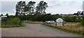
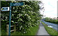
Kiveton Community Woodland Car Park
Kiveton Park, South Yorkshire
Kiveton Community Woodland stands on the site of the old Kiveton Park Colliery, having been transformed into a mini country park following the closure of the colliery in 1994. The whole area, including the pit tip, has now been tastefully landscaped, with areas of woodland, wetland and grassland attracting a wide variety of wildlife, and includes several miles of footpaths for walking. Much of the area is carpeted with wildflowers during the spring, including spectacular displays of cowslips, whilst the viewpoint near the summit of what was the pit tip has views extending for miles, right over to the Derbyshire hills. At the summit stand three huge stones https://www.geograph.org.uk/photo/6331083, whilst nearby is a cast iron sculpture called “Dreaming of Sky” https://www.geograph.org.uk/photo/5979369 depicting a pit pony hauling a tub of coal and commemorating the lives of the many ponies that once worked down Kiveton Pit.
This picture shows the car park at the Hard Lane entrance to the park. Further parking is available near the Colliery Road entrance adjacent to Kiveton Bridge railway station.
Image: © Mike Nield
Taken: 11 Aug 2013
0.11 miles
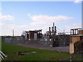
8
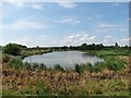
At Kiveton Waters
A popular venue for local anglers.
Image: © Neil Theasby
Taken: 25 Jul 2014
0.12 miles
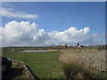
9

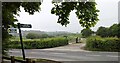
Kiveton Pit Top from Hard Lane
Public footpath leading from Hard Lane into Kiveton Community Woodland. The wooded hill in the background is the landscaped remains of the old Kiveton Park Colliery spoil heap (pit tip). The colliery closed in 1994 and the land it occupied was taken over by the Land Trust and subsequently transformed into the mini country park we know today as Kiveton Community Woodland with the old pit tip as its centrepiece. The 140-acre site includes areas of woodland, wetland and grassland attracting a wide variety of wildlife, and includes several miles of footpaths for walking.
Image: © Mike Nield
Taken: 27 Oct 2019
0.14 miles