Tommy Flockton?s from Hard Lane
Introduction
The photograph on this page of Tommy Flockton?s from Hard Lane by Mike Nield as part of the Geograph project.
The Geograph project started in 2005 with the aim of publishing, organising and preserving representative images for every square kilometre of Great Britain, Ireland and the Isle of Man.

There are currently over 7.5m images from over 14,400 individuals and you can help contribute to the project by visiting https://www.geograph.org.uk
Tommy Flockton?s from Hard Lane
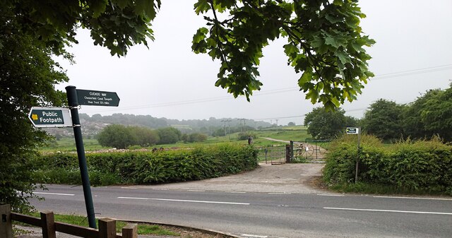
Image: © Mike Nield Taken: 16 Jun 2020
Kiveton Park, South Yorkshire Pennyholme Marsh, better known to locals as “Tommy Flockton's”, is an area of low-lying wetland straddled between the Norwood Tunnel on the Chesterfield Canal and the Sheffield to Lincoln railway line to the east of the village of Kiveton Park in South Yorkshire; Tommy Flockton being a local farmer who once owned the land (circa 1833). The lower, central part of the marsh floods extensively in winter, but the surrounding higher ground remains dry and is grazed by many horses, said to be the descendants of the old pit ponies that once worked down Kiveton Park Colliery which, until its closure in 1994, stood across the road on the west side of Hard Lane. Lying to the east of Hard Lane, a public footpath passes over the marsh to join up with the Chesterfield Canal by the eastern portal of the Norwood Tunnel. This path is part of the Cuckoo Way, a 46-mile Long Distance Path following the route of the canal from Chesterfield to West Stockwith where the canal joins the River Trent. The tunnel itself passes beneath the marsh, its line marked by a succession of spoil mounds from the construction shafts. It was here where the tunnel collapsed in October 1907 forcing its closure. The marsh is also crossed on its northern side by the Broad Bridge Dyke, which takes its water from nearby Pebley and Harthill Reservoirs to feed the Chesterfield Canal. It flows for approximately two miles before finally emptying into the canal via a spectacular cascade https://www.geograph.org.uk/photo/6248502 near Kiveton Park Station. During the mid-1980s, four local folk musicians formed a band under the name “Tommy Flockton’s” and even had their own signature tune which was named after them. It can be heard here https://www.flickr.com/photos/128783627@N03/24493661149/in/album-72157682701458263/
Images are licensed for reuse under creativecommons.org/licenses/by-sa/2.0
Image Location


Leaflet Map data © OpenStreetMap
Latitude
53.336556
Longitude
-1.257643