IMAGES TAKEN NEAR TO
Waverley Avenue, SHEFFIELD, S26 6RH
Introduction
This page details the photographs taken nearby to Waverley Avenue, S26 6RH by members of the Geograph project.
The Geograph project started in 2005 with the aim of publishing, organising and preserving representative images for every square kilometre of Great Britain, Ireland and the Isle of Man.

There are currently over 7.5m images from over14,400 individuals and you can help contribute to the project by visiting https://www.geograph.org.uk
Image Map
Images are licensed for reuse under creativecommons.org/licenses/by-sa/2.0
Notes
- Clicking on the map will re-center to the selected point.
- The higher the marker number, the further away the image location is from the centre of the postcode.
Image Listing (30 Images Found)
Images are licensed for reuse under creativecommons.org/licenses/by-sa/2.0
Image
Details
Distance
1
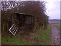
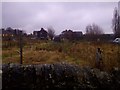
Tumbledown allotment shack
Rear of Wesley Road North allotments looking west towards Wales High School
Image: © Karl Smt
Taken: 10 Feb 2013
0.13 miles
2
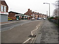
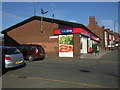
Kiveton Park - Junction of Wesley Road and Station Road
Image: © Alan Heardman
Taken: 27 Jan 2009
0.14 miles
4
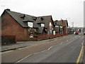
Kiveton Park - Youth and Community Centre
Image: © Alan Heardman
Taken: 27 Jan 2009
0.14 miles
7
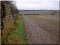
Stone Wall at the Rear of Wesley Road North Allotments
Looking west towards Wales High School
Image: © Karl Smt
Taken: 10 Feb 2013
0.17 miles
8
Wesley Road North Allotments
Looking south from the rear boundary wall over the allotments to the top end of Wesley Road
Image: © Karl Smt
Taken: 10 Feb 2013
0.18 miles
9
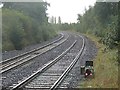
Shunting Signal at Kiveton Bridge Station
Kiveton Park, South Yorkshire.
Not many years ago, this view from the end of Platform 2 at Kiveton Bridge station would have been a very different scene. The line of trees on the right would not have existed and straight ahead we would have been looking directly at Kiveton Park Colliery, which would have then dominated this scene. Just beyond the still extant ground position light in the foreground would have been points leading to sidings in the pit yard, and from this vantage point we would have had a clear view of wagons being loaded with coal.
The pit closed in 1994 and the whole area it occupied, including the pit tip, has since been transformed into the mini country park we know today as Kiveton Community Woodland. The sidings within the pit yard would have been lifted soon after the pit's closure, although the points on the main running line remained for some time afterwards. However, they too have now gone, and yet the redundant ground shunting signal remains to this day and, as can be seen from this picture, is still illuminated.
Image: © Mike Nield
Taken: 30 Sep 2017
0.18 miles
10

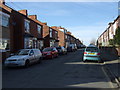
Kiveton Bridge Station - View from Footbridge
Image: © Alan Heardman
Taken: 27 Jan 2009
0.19 miles